|
January, 15, 2012: South from the Wrong Turn
Comment via blog |
|
January, 15, 2012: South from the Wrong Turn
Comment via blog |
|
|
 It's always nice to learn something new and it's always good, though not
always nice, to learn when you're wrong. A bit of learning in both
categories resulted from
a thread over at American Road Magazine Forum. A guy
named BlueRidgeMike started the thread about some combination Robert E Lee
& Dixie Highway markers that the United Daughters of the Confederacy
put up. I knew of the markers, had seen a couple in North Carolina, but I
didn't know there was one in Ohio. That's the something new I learned.
It's always nice to learn something new and it's always good, though not
always nice, to learn when you're wrong. A bit of learning in both
categories resulted from
a thread over at American Road Magazine Forum. A guy
named BlueRidgeMike started the thread about some combination Robert E Lee
& Dixie Highway markers that the United Daughters of the Confederacy
put up. I knew of the markers, had seen a couple in North Carolina, but I
didn't know there was one in Ohio. That's the something new I learned.
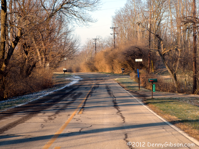
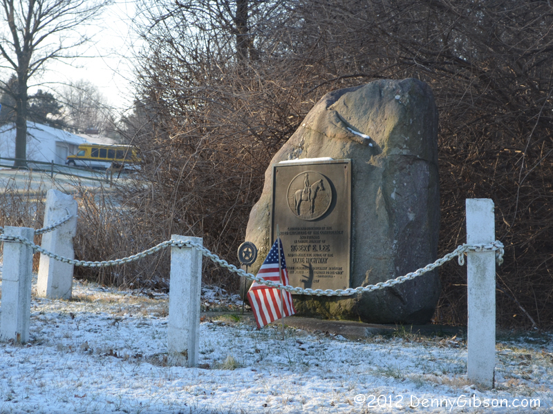
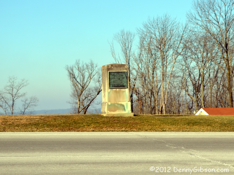
Surely I must have passed by the marker on my July drive on the Dixie. I found the marker on Google Street View and saw that it faced north and was backed by trees. It would be very easy to miss when northbound. What about southbound? The marker is south of Franklin, Ohio, where two Dixie Highway alignments split. I mean exactly where they split. In July, I had followed some simplified directions when headed south and turned west with OH-4/OH-73. That was several hundred yards too soon and caused me to miss the marker and over a mile of two-lane Dixie Highway. That was the first thing I learned I had wrong. Once I realized that I had not merely driven by the marker without seeing it but had made a wrong turn, my thoughts moved from just visiting the marker to correcting my mistake. Even though the marker is just over twenty miles from my home, it occurred to me that I might leverage the drive even more. I sent a note to Dixie Highway expert Russell Rein (a.k.a., ypsi-slim) hoping to sort out the south end of the two alignments which I'd just skipped over in July. Russell was on his own road trip but responded as soon as he got home before digging in to answer my question. He copied Mike Buettner and I slapped my forehead. Mike is President of the Ohio Chapter of the Lincoln Highway Association. In addition to producing an excellent guide to the Lincoln Highway in Ohio, he has written well researched shorter articles on other Ohio roads including the Dixie Highway. I was well aware of and had read the article and can't begin to explain why I didn't think of it either in July or now. It explained the southern rejoining and revealed several other goofs in my July path. With sincere thanks to both Russell and Mike, I set off to correct the errors of my way. |
|
|
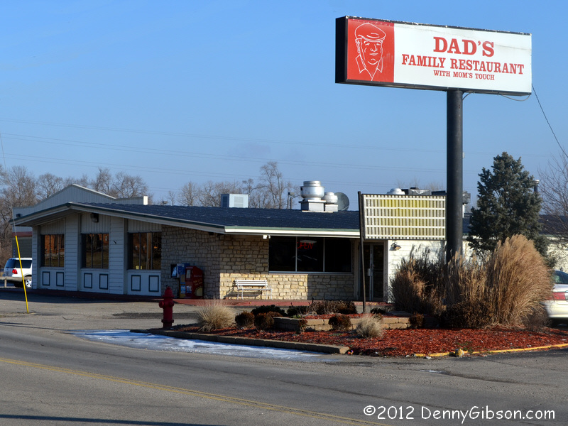

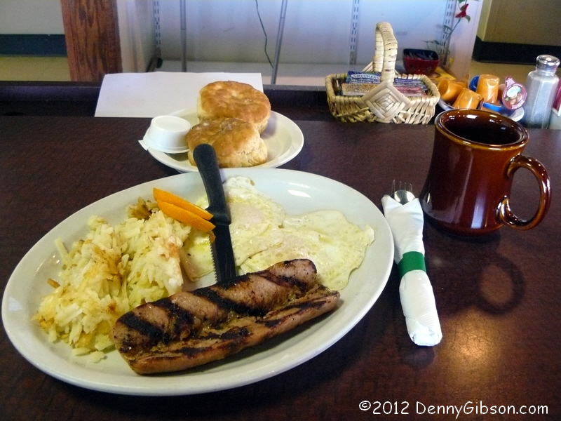 With the drive-by photo of a 17 degree rock out of the way, it was time to
give the trip a proper start with a stop at
Dad's Family Restaurant for a hot breakfast. I sat at
the counter and got a shot of the section to my left moments before a few
groups moved in there. Booths behind me were already filled. Smoked
sausage isn't really rare but not all that many restaurants serve it. I
tend to order it when I see in on the menu and that's what I did today. I
didn't quite make it through the potatoes or biscuits but I completely did
in the eggs and sausage.
With the drive-by photo of a 17 degree rock out of the way, it was time to
give the trip a proper start with a stop at
Dad's Family Restaurant for a hot breakfast. I sat at
the counter and got a shot of the section to my left moments before a few
groups moved in there. Booths behind me were already filled. Smoked
sausage isn't really rare but not all that many restaurants serve it. I
tend to order it when I see in on the menu and that's what I did today. I
didn't quite make it through the potatoes or biscuits but I completely did
in the eggs and sausage.
|
|
|
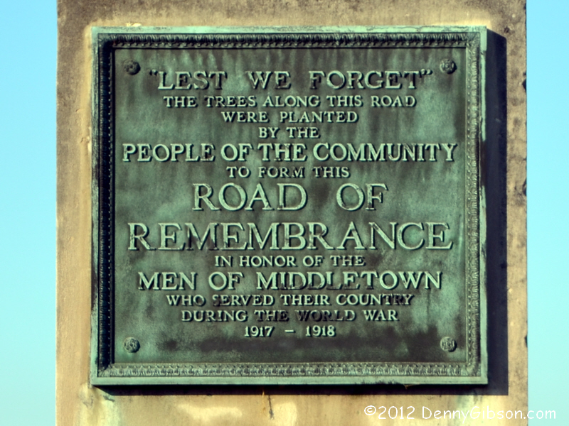
 One of my earlier missteps had been an overly simplified pass through
Middletown on modern state highway routings. Although I'm no stranger to
Middletown, I doubt I've been there much in the winter time. With the
leaves all gone, I was struck by the number of stately homes along Main
Street (the true Dixie Highway) and spotted three of four
Road to Remembrance monuments that I hadn't noticed in
the past. The monument's plaque can be read here.
Had it been a tad warmer, I'd have likely walked about for some pictures
of the mansions but instead I've put Middletown down for a future visit.
One of my earlier missteps had been an overly simplified pass through
Middletown on modern state highway routings. Although I'm no stranger to
Middletown, I doubt I've been there much in the winter time. With the
leaves all gone, I was struck by the number of stately homes along Main
Street (the true Dixie Highway) and spotted three of four
Road to Remembrance monuments that I hadn't noticed in
the past. The monument's plaque can be read here.
Had it been a tad warmer, I'd have likely walked about for some pictures
of the mansions but instead I've put Middletown down for a future visit.
|
|
|

 In Hamilton, Ohio, where my July route had also been over simplified (or
maybe just wrong), I guess I finally felt sufficiently embarrassed by my
drive-by camera clicking that I actually stepped out of the car. With
justification, Hamilton calls itself the
City of
Sculpture. The American Cape, a bigger than life bronze of the
city's namesake, is just one of many sculptures permanently decorating
Hamilton. Other sculptures appear temporarily now and then and at the
biennial Hamilton Ice Festival, which I attended
last year, the sculptures themselves
are temporary.
In Hamilton, Ohio, where my July route had also been over simplified (or
maybe just wrong), I guess I finally felt sufficiently embarrassed by my
drive-by camera clicking that I actually stepped out of the car. With
justification, Hamilton calls itself the
City of
Sculpture. The American Cape, a bigger than life bronze of the
city's namesake, is just one of many sculptures permanently decorating
Hamilton. Other sculptures appear temporarily now and then and at the
biennial Hamilton Ice Festival, which I attended
last year, the sculptures themselves
are temporary.
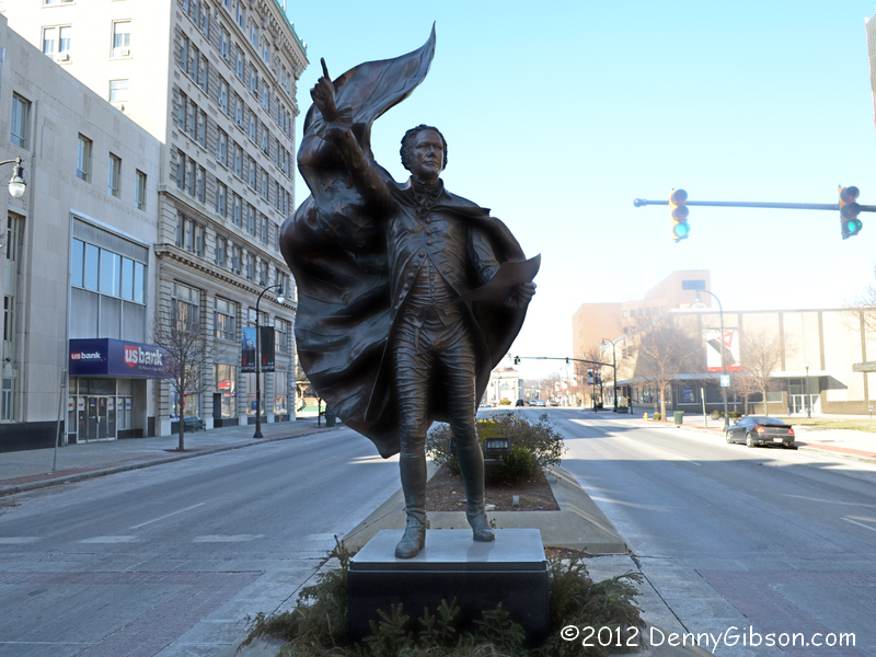
The statue of Alexander Hamilton isn't quite on the Dixie Highway. Mike Buettner's 2006 article describes the Dixie Highway as running "southerly with Second Street/U.S. 127". US-127 currently follows Martin Luther King Boulevard/Fourth Street. DeLorme Street Atlas 2011 shows it on Third Street. The sunlit building behind Alex in the first picture is the Butler County courthouse. Second Street passes just on this side of it. Third Street is right behind me and the current US-127 a block beyond. So, if you like the DH on Second or Third, The American Cape is just a half block away. If you favor current US-127 routing, it's a block and a half. |
|
|
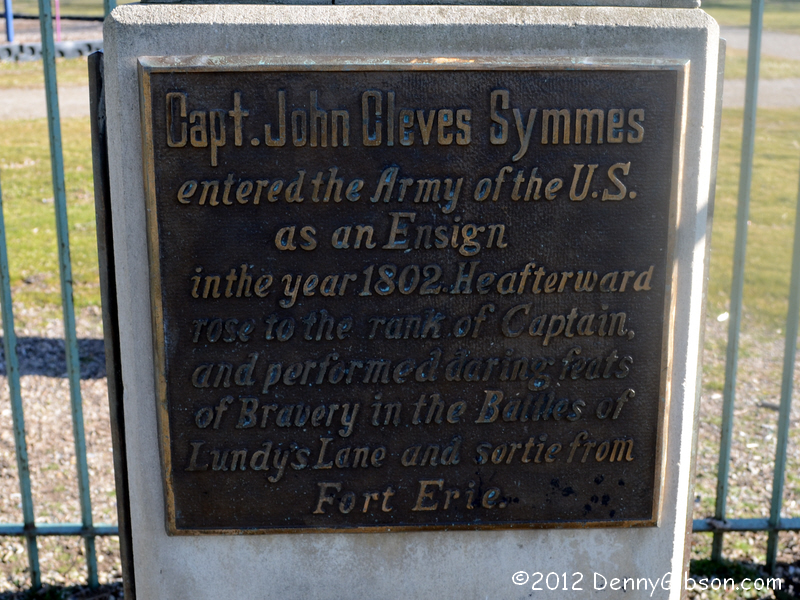
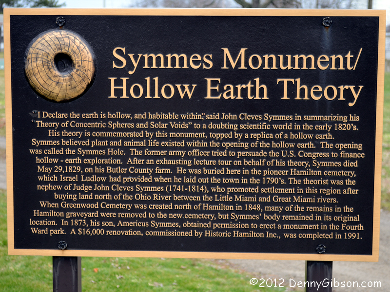
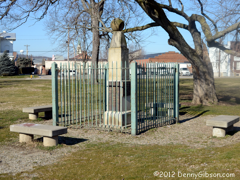 Similar relationships exist three blocks away at Symmes Park. Third Street
runs right by its west boundary, second Street is a block away, and MLK
Boulevard, after veering away from Fourth, is now a couple of blocks to
the east. John Cleves Symmes was an early land speculator whose names
(both Cleves and Symmes and probably John) are spread about south west
Ohio. For example, I live in Symmes Township. His nephew, John Cleves
Symmes, Jr., doesn't have nearly as many things named after him but this
park is all junior's. The younger Symmes was both a
soldier and a
philosopher. This monument, which once marked
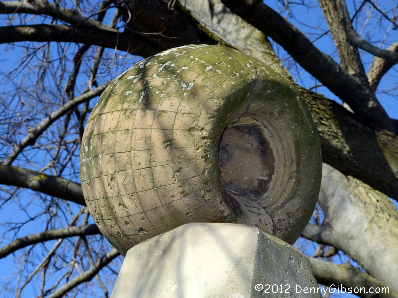
his grave, now stands at the center of a park to keep his theories from
being lost. His "Theory of Concentric Spheres" led, quite
naturally, to the "Hollow Earth Theory".
I believe that what looks a little like a tongue protruding from the
hollow earth atop the monument is actually a stairway (probably not to
scale) for entry and exit. How gravity operated on the stairway and how
treads are distinguished from risers is not entirely clear.
Similar relationships exist three blocks away at Symmes Park. Third Street
runs right by its west boundary, second Street is a block away, and MLK
Boulevard, after veering away from Fourth, is now a couple of blocks to
the east. John Cleves Symmes was an early land speculator whose names
(both Cleves and Symmes and probably John) are spread about south west
Ohio. For example, I live in Symmes Township. His nephew, John Cleves
Symmes, Jr., doesn't have nearly as many things named after him but this
park is all junior's. The younger Symmes was both a
soldier and a
philosopher. This monument, which once marked
his grave, now stands at the center of a park to keep his theories from
being lost. His "Theory of Concentric Spheres" led, quite
naturally, to the "Hollow Earth Theory".
I believe that what looks a little like a tongue protruding from the
hollow earth atop the monument is actually a stairway (probably not to
scale) for entry and exit. How gravity operated on the stairway and how
treads are distinguished from risers is not entirely clear.
|
|
|
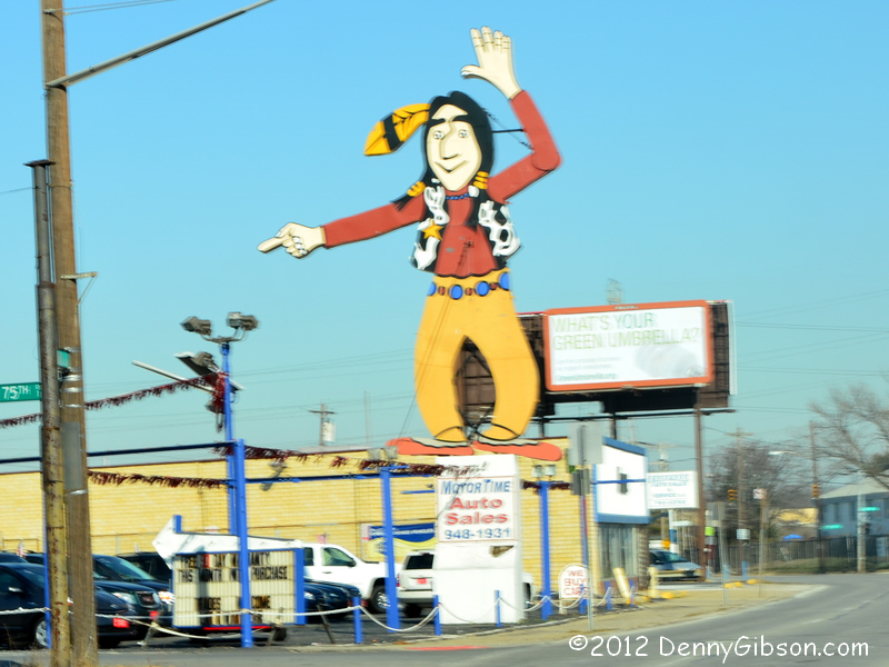
 In July I made a wrong assumption here and followed Vine Street to
downtown Cincinnati. The correct path stays with OH-4 and moves onto
Paddock Road which joins the Cincinnati-Dayton Road alignment at
Reading Road/US-42. For some distance north of the intersection, Vine
Street is lined with "buy here - pay here" used car dealers.
There are plenty of signs and one lot even has a giant cougar that once
topped a Mercury dealership. But one sign has become a landmark.
"Where Paddock meets Vine at the big Indian sign" was once the
unmistakable location of Cherokee Motors. Repainted in 2007, he now marks
the home of Motor Time used cars. Although I was driving south, the
picture was taken facing north. I believe there are a few tire shops on
Vine and there are a couple of car lots on Paddock, but there is a
definite shift from whole cars to components after the turn.
In July I made a wrong assumption here and followed Vine Street to
downtown Cincinnati. The correct path stays with OH-4 and moves onto
Paddock Road which joins the Cincinnati-Dayton Road alignment at
Reading Road/US-42. For some distance north of the intersection, Vine
Street is lined with "buy here - pay here" used car dealers.
There are plenty of signs and one lot even has a giant cougar that once
topped a Mercury dealership. But one sign has become a landmark.
"Where Paddock meets Vine at the big Indian sign" was once the
unmistakable location of Cherokee Motors. Repainted in 2007, he now marks
the home of Motor Time used cars. Although I was driving south, the
picture was taken facing north. I believe there are a few tire shops on
Vine and there are a couple of car lots on Paddock, but there is a
definite shift from whole cars to components after the turn.
|
|
|
 I've driven by this statue at Rockdale and Reading innumerable times and
I've seen many pictures. That familiarity made me think I had stood in
front of it but I now believe that, prior to today, I may not have.
Cincinnati suffered race riots in 1967 and 1968. The ones of 1968,
triggered by the assassination of Martin Luther King, Jr., were horrendous
and, in remembering them, I'd forgotten those of 1967. Or maybe all the
insanity just blurs together. I was reminded of those 1967 events when I
went looking for some information about the statue. In May of 1967,
Posteal Laskey, Jr., the supposed Cincinnati Strangler, was convicted of
one murder. Laskey was black; The victim white. In the climate of the day,
that led to protests which led to at least one arrest which led to a
meeting at the foot of this statue on June 12. That meeting erupted into
several days of rioting that hospitalized more than seventy people.
I've driven by this statue at Rockdale and Reading innumerable times and
I've seen many pictures. That familiarity made me think I had stood in
front of it but I now believe that, prior to today, I may not have.
Cincinnati suffered race riots in 1967 and 1968. The ones of 1968,
triggered by the assassination of Martin Luther King, Jr., were horrendous
and, in remembering them, I'd forgotten those of 1967. Or maybe all the
insanity just blurs together. I was reminded of those 1967 events when I
went looking for some information about the statue. In May of 1967,
Posteal Laskey, Jr., the supposed Cincinnati Strangler, was convicted of
one murder. Laskey was black; The victim white. In the climate of the day,
that led to protests which led to at least one arrest which led to a
meeting at the foot of this statue on June 12. That meeting erupted into
several days of rioting that hospitalized more than seventy people.
The William Granville Hastings sculpture was presented to the city in 1902 by Civil War veteran Captain Charles Clinton. Other copies exist in Illinois and Iowa. The female figure at the base has just finished writing a phrase from Lincoln's second inaugural address, "With malice toward none...". There was a lady standing at the statue when I approached it today. She asked me for seventy-five cents "for the bus". I dug out a dollar bill and handed it to her. As I raised my camera and moved toward the statue she asked,"You taking pictures?". "Yes", I told her. "I've always liked this statue but don't have any pictures." She then told me the bus fare was $2.25 and wondered if I had that. I told her no and handed her the change in my pocket. Maybe sixty or seventy cents. I took my pictures and wished her luck. "Thanks for the thought", she said. It was a strange exchange. She was gracious and had thanked me for the dollar and again for the change. She was grateful but not overwhelmingly so. Why should she be? I hadn't strained myself. We both knew that I could have easily spared another dollar even though I said no. Maybe she was really collecting bus fare and maybe not. I can never tell. Maybe the fare really was $2.25 or maybe it was the originally requested 75 cents or maybe it was something else. Whatever the purpose of her requests, I had helped her some but not enough. "Thanks for the thought". |
|
|
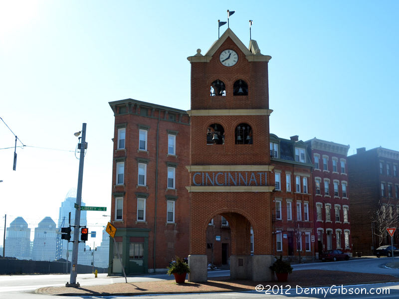

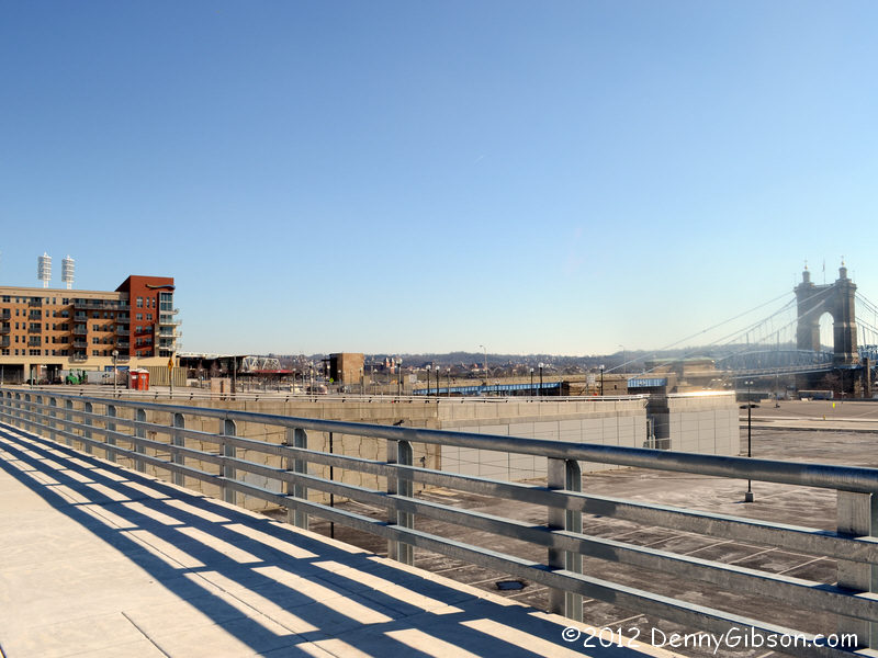
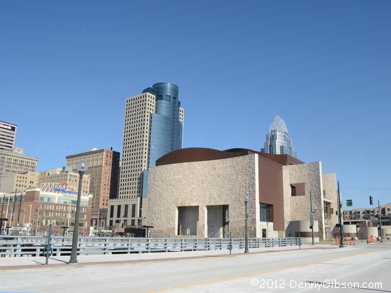 There really isn't a whole lot of picturesque scenery along Reading Road.
These pictures were all taken near or in downtown Cincinnati with the
bright low level sun giving me fits. The first two are of the tower that
marks the "gateways" to downtown and to Over The Rhine. Washed
out buildings at the left of the first picture are the twin Proctor &
Gamble towers and the new Great American Insurance building. The carillon
is part of the
Cincinnati Gateway Program. The third picture is of
the Horseshoe Casino construction and the fourth is of the
streets near the Banks
Project. At least it was supposed to be streets but I was about fifty
feet too short to show the current approach to the Roebling Bridge which
is what I had in mind. The last picture was taken from the same spot as
the bridge picture. The building in the foreground is the
National
Underground Railroad Freedom Center. The tower to the left is the
Scripps Center. I'm told it's supposed to invoke the Scripps Howard
lighthouse logo but I always thought it looked like the big menacing robot
in Disney's The Black Hole. The other skyscraper is the other side
of the Great American Insurance building. a.k.a. The Great American Tower.
It is currently the tallest building in Cincinnati. The structure on top
was somehow inspired by Princess Diana's tiara. It lights up at night.
There really isn't a whole lot of picturesque scenery along Reading Road.
These pictures were all taken near or in downtown Cincinnati with the
bright low level sun giving me fits. The first two are of the tower that
marks the "gateways" to downtown and to Over The Rhine. Washed
out buildings at the left of the first picture are the twin Proctor &
Gamble towers and the new Great American Insurance building. The carillon
is part of the
Cincinnati Gateway Program. The third picture is of
the Horseshoe Casino construction and the fourth is of the
streets near the Banks
Project. At least it was supposed to be streets but I was about fifty
feet too short to show the current approach to the Roebling Bridge which
is what I had in mind. The last picture was taken from the same spot as
the bridge picture. The building in the foreground is the
National
Underground Railroad Freedom Center. The tower to the left is the
Scripps Center. I'm told it's supposed to invoke the Scripps Howard
lighthouse logo but I always thought it looked like the big menacing robot
in Disney's The Black Hole. The other skyscraper is the other side
of the Great American Insurance building. a.k.a. The Great American Tower.
It is currently the tallest building in Cincinnati. The structure on top
was somehow inspired by Princess Diana's tiara. It lights up at night.
While the new baseball stadium was being built, my sailor son was in town and we did some sightseeing. When he saw the sign announcing construction of the Great American Ballpark, he thought that was pretty cool and commented on how neat it was that they didn't sell out to some faceless corporation. It hurt to have to tell him about the Great American Insurance Company. |
|
|
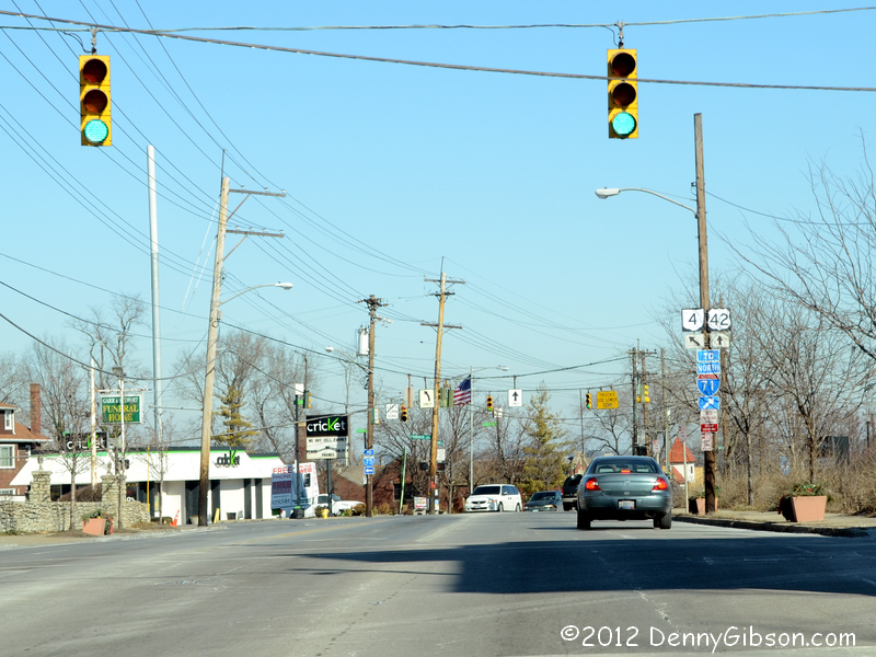 I didn't get a picture of the meeting of the two Dixie Highway alignments
on the way down but here is one taken northbound. OH-4, which angles off
to the northwest, is the earlier alignment and US-42 the later one.
I didn't get a picture of the meeting of the two Dixie Highway alignments
on the way down but here is one taken northbound. OH-4, which angles off
to the northwest, is the earlier alignment and US-42 the later one.
|
|
|
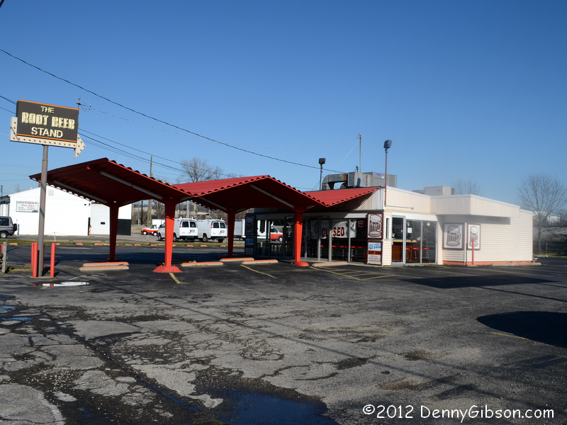
 The Root Beer
Stand started life in 1957 as an A & W. In those days, it was
US-25 that ran by the front door. The A & W franchise ended in 1982 but it
didn't make a lot of difference. The root beer is still made on premise,
it's still mighty good, and the place is still mighty crowded in the
summer. On January 10, their Facebook page announced that the 2012 opening
was just 76 days away.
The Root Beer
Stand started life in 1957 as an A & W. In those days, it was
US-25 that ran by the front door. The A & W franchise ended in 1982 but it
didn't make a lot of difference. The root beer is still made on premise,
it's still mighty good, and the place is still mighty crowded in the
summer. On January 10, their Facebook page announced that the 2012 opening
was just 76 days away.
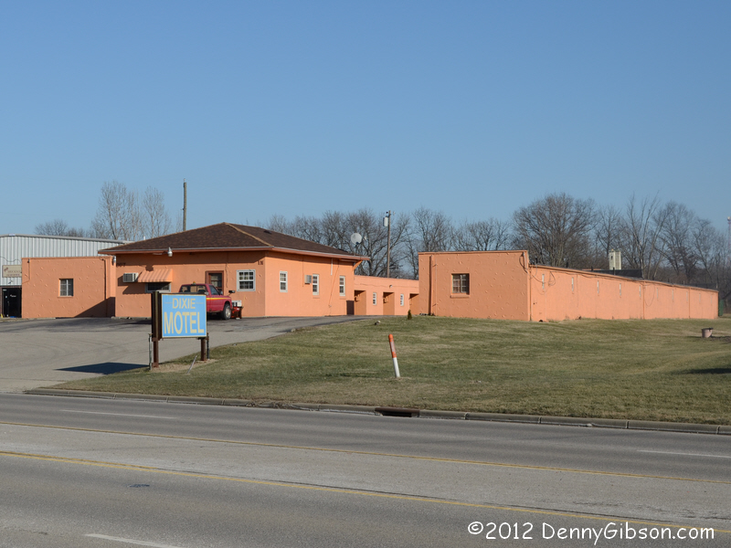
I grabbed a picture of the Dixie Motel simply because it was one of the few places that looked like it might have been around when this was the Dixie Highway. It's a little south of what was once Blue Ball with a Middletown address. |
|
|

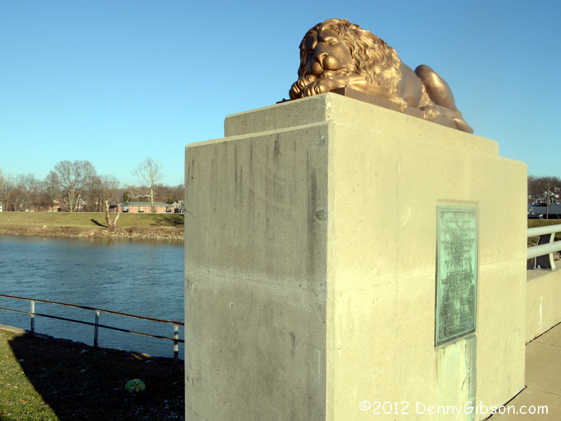
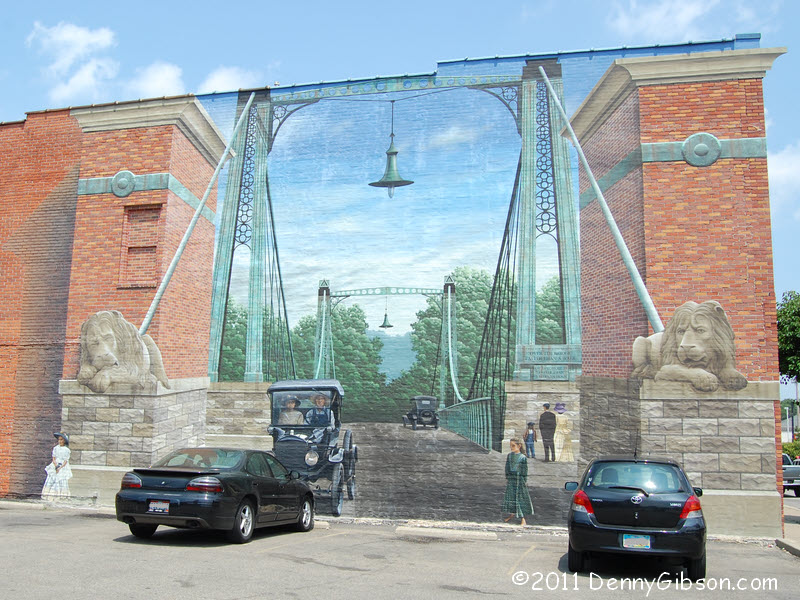
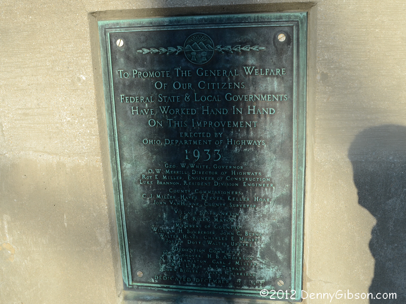
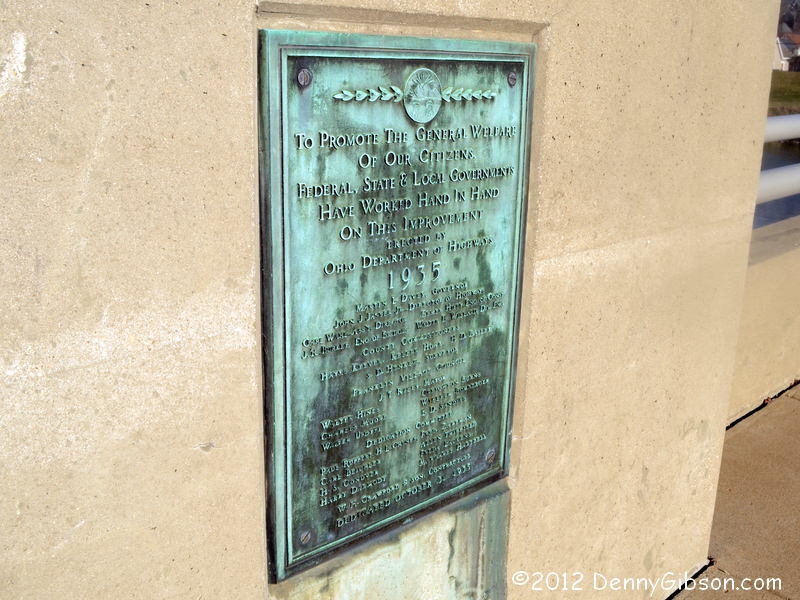
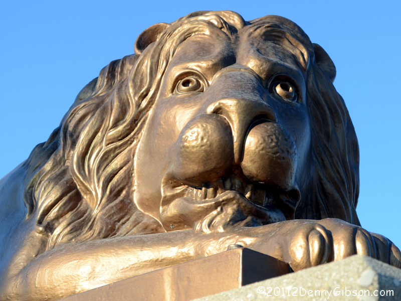 My trip journal from July includes a picture of a mural depicting the
impressive suspension bridge that crossed the Great Miami River from 1873
to 1933. The four cast iron lions from that bridge were moved to its
replacement and I intended to get pictures of the cats at their new home
but forgot. Nearly six months late, I got the pictures today. My picture
from July is here. An
online article says the bridge was built in 1932-33 by
the Dodge Hussey Company. Apparently somebody found some work to hold off
completion until a new governor took over in January of 1935. The east end
of the bridge has a plaque dated 1933 with
George White shown as governor. A very similar plaque on the west end
shows 1935 as the year and Martin L. Davey as the governor. Both were from
the same party (Democrat) which might make switching governors in the middle of a stream a little
safer.
My trip journal from July includes a picture of a mural depicting the
impressive suspension bridge that crossed the Great Miami River from 1873
to 1933. The four cast iron lions from that bridge were moved to its
replacement and I intended to get pictures of the cats at their new home
but forgot. Nearly six months late, I got the pictures today. My picture
from July is here. An
online article says the bridge was built in 1932-33 by
the Dodge Hussey Company. Apparently somebody found some work to hold off
completion until a new governor took over in January of 1935. The east end
of the bridge has a plaque dated 1933 with
George White shown as governor. A very similar plaque on the west end
shows 1935 as the year and Martin L. Davey as the governor. Both were from
the same party (Democrat) which might make switching governors in the middle of a stream a little
safer.
|
|
|
| [Site Home] [Contact] |