Off to Puget Sound
Comment via blog
Prev
Next


|
Day 6: June 11, 2021 Off to Puget Sound Comment via blog |
Prev Next |
|
|
|

 There are a total of eight Percy's Place locations but, as one of their slogans
says, "Not a chain... Just a few good restaurants run by family and
friends." They have another slogan that claims "New England's
Largest Breakfast Menu". I'm sure that one is accurate, and I'm
fairly confident the other one is, too. I narrowed my desires down to a
half-dozen or so items before being forced to make a decision and ordering
an egg benedict. It was an excellent choice, but I
bet the others were too.
There are a total of eight Percy's Place locations but, as one of their slogans
says, "Not a chain... Just a few good restaurants run by family and
friends." They have another slogan that claims "New England's
Largest Breakfast Menu". I'm sure that one is accurate, and I'm
fairly confident the other one is, too. I narrowed my desires down to a
half-dozen or so items before being forced to make a decision and ordering
an egg benedict. It was an excellent choice, but I
bet the others were too.
Although I didn't realize it while I was there, this place and the motel where I spent the night are both on the Yellowstone Trail and I would pass them again before long. |
|
|


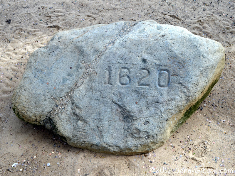
 I half anticipated just a drive by of Plymouth's famous boulder but it was
early enough that parking places were plentiful. I bought about a quarter
hour for half a dollar and did a short walkabout. The Mayflower II
has been recently restored and is looking good. Plymouth Rock doesn't
appear to have changed a bit since I saw it in
2012. However, it now rests
on some sort of supports. The sidewalks have had some commemorative
medallions embedded in them.
I half anticipated just a drive by of Plymouth's famous boulder but it was
early enough that parking places were plentiful. I bought about a quarter
hour for half a dollar and did a short walkabout. The Mayflower II
has been recently restored and is looking good. Plymouth Rock doesn't
appear to have changed a bit since I saw it in
2012. However, it now rests
on some sort of supports. The sidewalks have had some commemorative
medallions embedded in them.
|
|
|


 The Yellowstone Trail Association map indicates that the
most eastern bit of the trail is on North Street. That street is now
one-way eastbound so, although I did drive it. I actually started my
westward journey by turning onto its partner, Leyden Street. At the top of
the hill I turned on to Main Street and picked up the real YT when it
crossed North. I drove one block of original trail before encountering
something akin to a "Yellowstone Trail closed for remodeling"
and having to leave it. The detour wasn't a very long one and I was soon
cruising past my breakfast and bed spots and on my way the Emerald City.
The Yellowstone Trail Association map indicates that the
most eastern bit of the trail is on North Street. That street is now
one-way eastbound so, although I did drive it. I actually started my
westward journey by turning onto its partner, Leyden Street. At the top of
the hill I turned on to Main Street and picked up the real YT when it
crossed North. I drove one block of original trail before encountering
something akin to a "Yellowstone Trail closed for remodeling"
and having to leave it. The detour wasn't a very long one and I was soon
cruising past my breakfast and bed spots and on my way the Emerald City.
|
|
|


 They do not follow exactly the same path, but, like US-20, the Yellowstone
Trail dives right into the Boston area congestion. At one point, I saw the
big Citgo sign off in the distance and flirted with the idea of tackling
the terminus again. Fortunately a GPS directed turn removed it from my
sight and I quickly pushed that crazy idea out of my mind. The white car
in the second picture is wearing "student driver" signs. I can't
even imagine learning to drive here although traffic wasn't all that bad
where I spotted the student. Eventually, I escaped and I hope the student
driver did, too.
They do not follow exactly the same path, but, like US-20, the Yellowstone
Trail dives right into the Boston area congestion. At one point, I saw the
big Citgo sign off in the distance and flirted with the idea of tackling
the terminus again. Fortunately a GPS directed turn removed it from my
sight and I quickly pushed that crazy idea out of my mind. The white car
in the second picture is wearing "student driver" signs. I can't
even imagine learning to drive here although traffic wasn't all that bad
where I spotted the student. Eventually, I escaped and I hope the student
driver did, too.
|
|
|


 In Massachusetts, much of the Yellowstone Trail became US-20 so all of
today's drive was through territory I passed through yesterday and much of
it was on the very same pavement. A little west of Brookfield, I found a
somewhat scenic stretch that apparently had not been absorbed by the
numbered highway. I followed it as far as I could, but at last had to
believe the signs and turn around.
In Massachusetts, much of the Yellowstone Trail became US-20 so all of
today's drive was through territory I passed through yesterday and much of
it was on the very same pavement. A little west of Brookfield, I found a
somewhat scenic stretch that apparently had not been absorbed by the
numbered highway. I followed it as far as I could, but at last had to
believe the signs and turn around.
|
|
|
 I wasn't surprised to find the Historic 20 Visitor Center and the
restaurant beside it closed on this pass. I took advantage of the
opportunity to grab a picture of the whole building. The Pegasus sign is
just one of several items remaining from when this was a gas station. The
picture on page 16 of Bryon Farr's book is of the pumps that used to stand
in front.
I wasn't surprised to find the Historic 20 Visitor Center and the
restaurant beside it closed on this pass. I took advantage of the
opportunity to grab a picture of the whole building. The Pegasus sign is
just one of several items remaining from when this was a gas station. The
picture on page 16 of Bryon Farr's book is of the pumps that used to stand
in front.
|
|
|
 The Roadside America app on my Garmin alerted me to this big beaver
yesterday but I didn't bother stopping. Today, because there has been so
little camera fodder, I did.
The Roadside America app on my Garmin alerted me to this big beaver
yesterday but I didn't bother stopping. Today, because there has been so
little camera fodder, I did.
|
|
|
 I wanted to cover as much ground as possible today, and because I was
traveling through territory I'd been in only yesterday, I didn't mind
traveling later than usual and getting into the dim of evening. I had a
reservation at a chain motel where I checked in a little after 7:00 PM.
The restaurant next door had an 8:00 closing time. That was plenty of time
to enjoy some fabulous Chicken Marsala at
Trattoria Il
Vesuvio. And they didn't kick me out at 8:00.
I wanted to cover as much ground as possible today, and because I was
traveling through territory I'd been in only yesterday, I didn't mind
traveling later than usual and getting into the dim of evening. I had a
reservation at a chain motel where I checked in a little after 7:00 PM.
The restaurant next door had an 8:00 closing time. That was plenty of time
to enjoy some fabulous Chicken Marsala at
Trattoria Il
Vesuvio. And they didn't kick me out at 8:00.
|
|
|
| [Prev] [Site Home] [Trip Home] [Contact] [Next] |