Bugs & More
Prev
Next
|
Day 6: June 19, 2007 Bugs & More |
Prev Next |
|
|
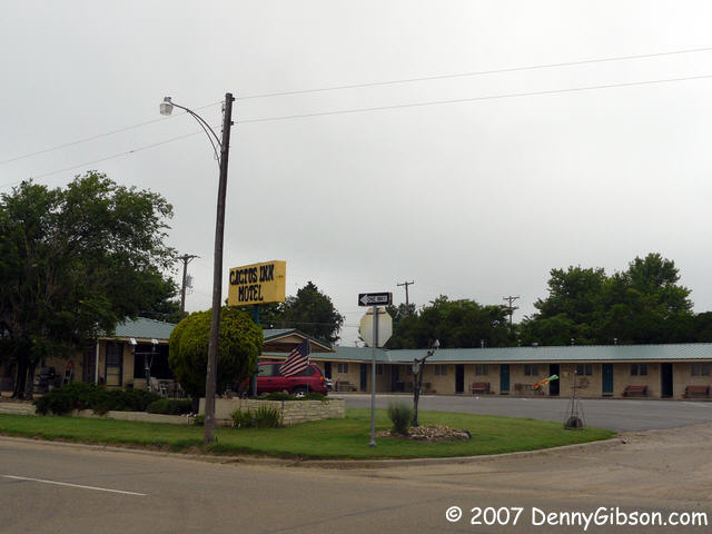
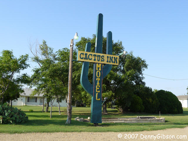 I stayed at the Cactus Inn in 2003 and, as I told Gordon when I checked
in, I've been looking forward to staying there again ever since. Gordon
& Jane Sheplor started by fixing up one room of the old motel to house
their visiting children and have ended up with one of the nicest classic
motels on Old 66. It's at least as nice as I remember and wi-fi has been
added. Check out my room if you'd like. A
"mom & pop" motel with a real mom & pop. (806) 779-2346.
Recommended.
I stayed at the Cactus Inn in 2003 and, as I told Gordon when I checked
in, I've been looking forward to staying there again ever since. Gordon
& Jane Sheplor started by fixing up one room of the old motel to house
their visiting children and have ended up with one of the nicest classic
motels on Old 66. It's at least as nice as I remember and wi-fi has been
added. Check out my room if you'd like. A
"mom & pop" motel with a real mom & pop. (806) 779-2346.
Recommended.
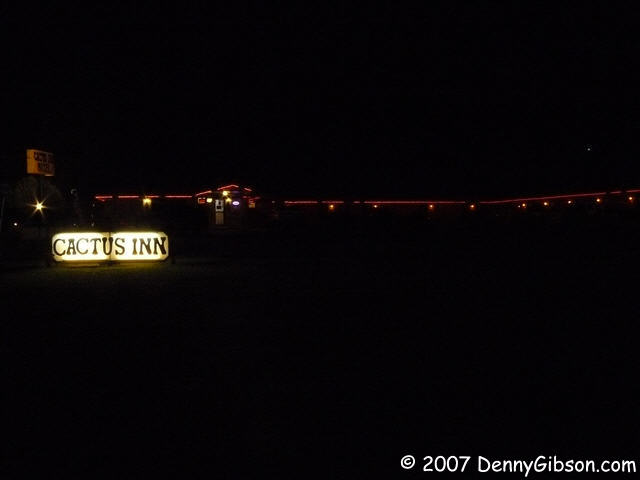
Last night, when I returned from eating and photographing the neon on the U Drop Inn, I couldn't resist a shot in the dark at the Cactus Inn. That's where that last picture comes from. |
|
|

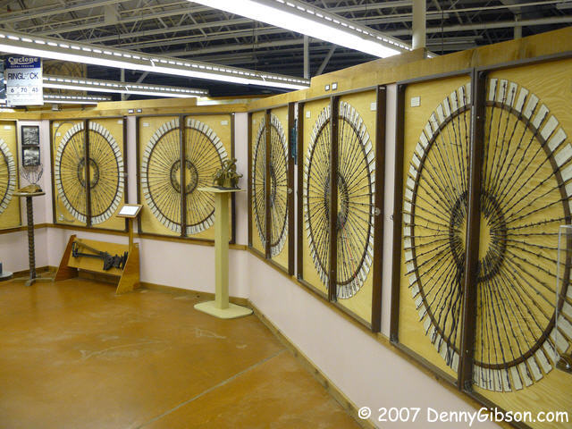

 I actually headed west this morning without visiting the
Devil's Rope
Museum but realized my mistake in about a mile. As I entered, Frank
Zander, from the Route 66 E-group was leaving but I didn't have the
presence of mind to get a picture. We'll meet again in Clinton, I'm sure.
I actually headed west this morning without visiting the
Devil's Rope
Museum but realized my mistake in about a mile. As I entered, Frank
Zander, from the Route 66 E-group was leaving but I didn't have the
presence of mind to get a picture. We'll meet again in Clinton, I'm sure.
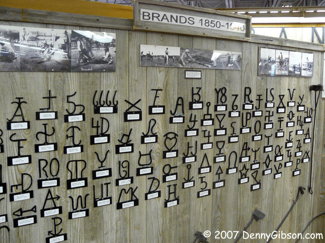
The museum is chock full of stuff related to ranching with an emphasis on fences and a real emphasis on barb wire fences. The Texas Old Route 66 Association Museum is housed here, too, so you get two for your donation. |
|
|
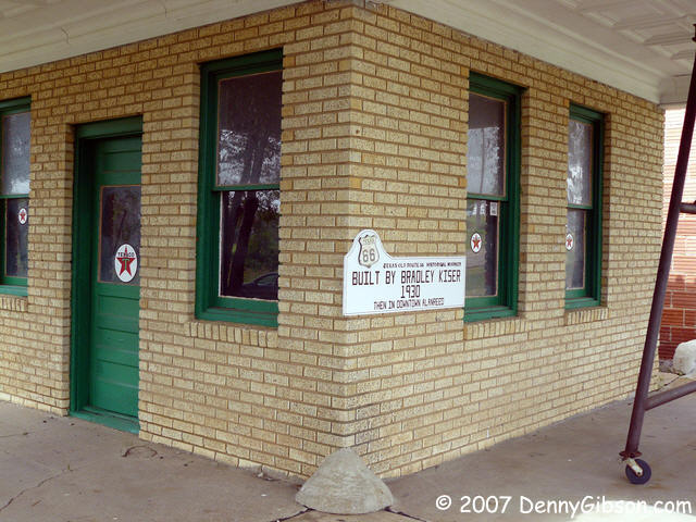

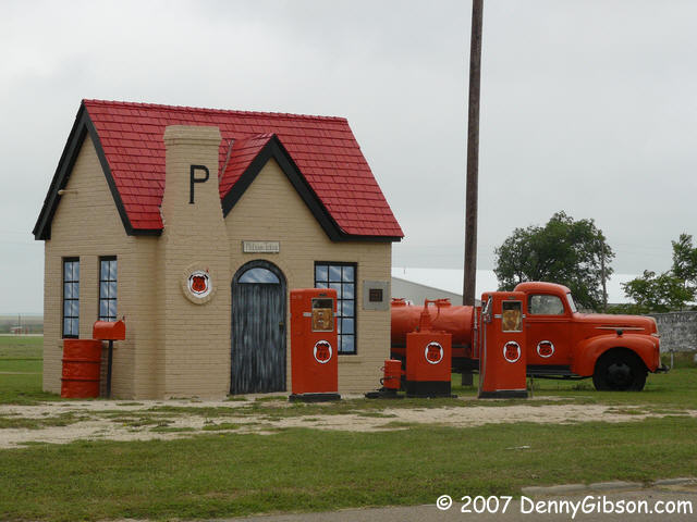 The Phillips station, the first ever in Texas, is in McLean. The Texaco
station is a bit farther west in Allanreed. I've stopped at both before
but this is the first I've noticed the home made "El Camino"
behind the station in Allanreed. Once upon a time, someone converted an
unidentified little car into a little truck complete with chrome side
rails on the bed. There's a story there.
The Phillips station, the first ever in Texas, is in McLean. The Texaco
station is a bit farther west in Allanreed. I've stopped at both before
but this is the first I've noticed the home made "El Camino"
behind the station in Allanreed. Once upon a time, someone converted an
unidentified little car into a little truck complete with chrome side
rails on the bed. There's a story there.
|
|
|

 The first picture was taken shortly after I could first make out Groom's
giant cross on
the horizon. It's about four miles away. Check out the bigger picture
(click on thumbnail) to locate it. The "Leaning Tower of Texas"
can also be seen in the long distance shot and I've included a closer shot
of both it and the cross. The cross now has a gift shop and I headed there
to get my Texas Passport stamped and so did E-groupers Sharon
& Mike Ward. They're on their way to Clinton from Arizona and I've
still got Tucumcari (The Wards were there last night.) ahead of me so,
when we returned to Sixty-Six they turned left and I turned right.
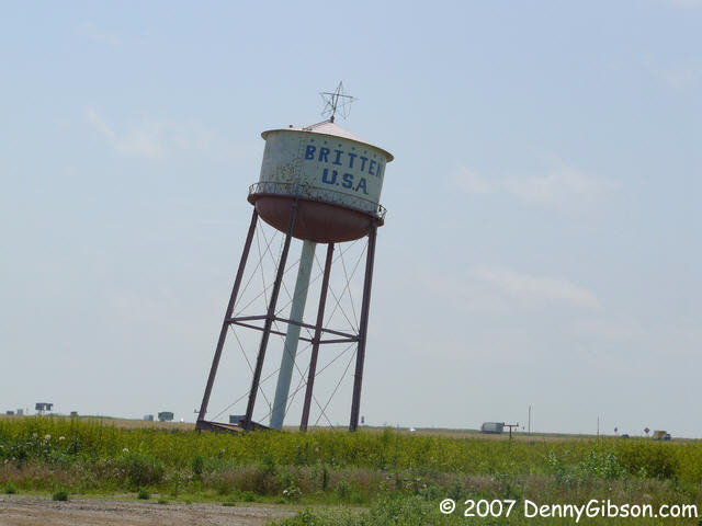
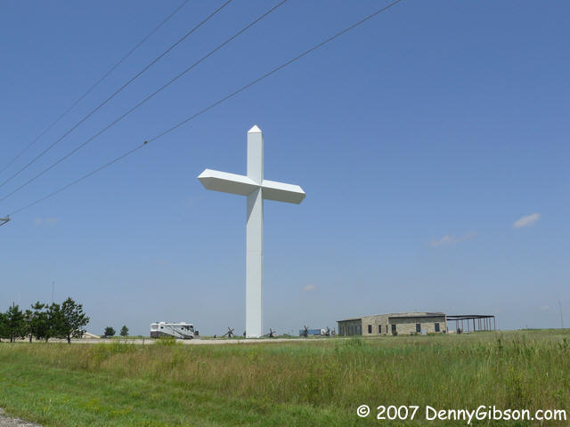
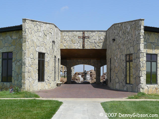
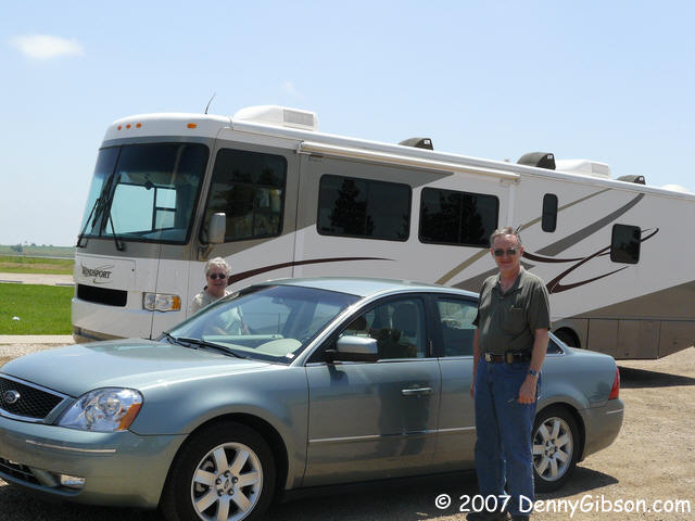
The first picture was taken shortly after I could first make out Groom's
giant cross on
the horizon. It's about four miles away. Check out the bigger picture
(click on thumbnail) to locate it. The "Leaning Tower of Texas"
can also be seen in the long distance shot and I've included a closer shot
of both it and the cross. The cross now has a gift shop and I headed there
to get my Texas Passport stamped and so did E-groupers Sharon
& Mike Ward. They're on their way to Clinton from Arizona and I've
still got Tucumcari (The Wards were there last night.) ahead of me so,
when we returned to Sixty-Six they turned left and I turned right.
|
|
|
 A few miles down the road from the big cross, my rental car chimed and I
eventually figured out that it was telling me it was hungry. Sometime last
night I remembered that I should get gas but hadn't thought of it since.
That chime was my, possibly too late, reminder. My GPS showed gas stations
about 25 miles away in either direction. While I was fairly sure there was
something closer than that, I had no idea where. No worry. Surely the tank
held at least a gallon when the warning activated and that 25 miles should
be no problem. But failing to buy gas wasn't my only goof. I had missed a
move to the north side frontage road and was burning my precious gas on
the wrong road. I started seeing signs of construction along the
expressway and then groups of workers and paving equipment. Breaks in the
pavement, a front loader heading toward me, and a "Road Ends"
sign made me think I might be in trouble. The driver of the loader and a
big dump truck looked at me quizzically as they drove by and I turned
around as quickly as I could; Fearing all the while that the car might
sputter to a spot at any time. I sloooowly followed the truck and loader
back to a point where a group of workmen stood. I asked where the nearest
gas might be and one of them explained that I'd have to head back a mile
or two to get on the expressway then could either continue west to gas
about 12 miles away or head back east for about 8 miles. Eight miles the
wrong way sounded better than twelve the right way. I reached the exit
and, besides being surprised that I made it, was surprised to see that
this was where the Bug Ranch was located. No stopping now, though. I
crossed over the interstate to the big Love's truck stop (which my little
Garmin apparently didn't know about). A car with the "proper"
left side filler was at every pump and most had another car behind them. I
waited (need I say?) nervously for a pump to open before another car
blocked it from the other end. One did. I filled up. I sighed and I headed
back to the Bug Ranch.
A few miles down the road from the big cross, my rental car chimed and I
eventually figured out that it was telling me it was hungry. Sometime last
night I remembered that I should get gas but hadn't thought of it since.
That chime was my, possibly too late, reminder. My GPS showed gas stations
about 25 miles away in either direction. While I was fairly sure there was
something closer than that, I had no idea where. No worry. Surely the tank
held at least a gallon when the warning activated and that 25 miles should
be no problem. But failing to buy gas wasn't my only goof. I had missed a
move to the north side frontage road and was burning my precious gas on
the wrong road. I started seeing signs of construction along the
expressway and then groups of workers and paving equipment. Breaks in the
pavement, a front loader heading toward me, and a "Road Ends"
sign made me think I might be in trouble. The driver of the loader and a
big dump truck looked at me quizzically as they drove by and I turned
around as quickly as I could; Fearing all the while that the car might
sputter to a spot at any time. I sloooowly followed the truck and loader
back to a point where a group of workmen stood. I asked where the nearest
gas might be and one of them explained that I'd have to head back a mile
or two to get on the expressway then could either continue west to gas
about 12 miles away or head back east for about 8 miles. Eight miles the
wrong way sounded better than twelve the right way. I reached the exit
and, besides being surprised that I made it, was surprised to see that
this was where the Bug Ranch was located. No stopping now, though. I
crossed over the interstate to the big Love's truck stop (which my little
Garmin apparently didn't know about). A car with the "proper"
left side filler was at every pump and most had another car behind them. I
waited (need I say?) nervously for a pump to open before another car
blocked it from the other end. One did. I filled up. I sighed and I headed
back to the Bug Ranch.
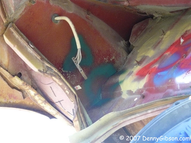
I had been in a Wal-Mart in Elk City buying glasses (That's a minor story, too.) and saw some 98 cent spray paint. I bought a can in anticipation of a full name signing at the Cadillac Ranch and now grabbed my paint to "sign a bug". Spray paint doesn't work too well in a strong cross wind so I had to settle for some shaky initials on a semi-enclosed surface. If you squint just right, there really is a D and a G there. Question of the Day: Why does any automobile manufacturer put the gas filler on the right hand side of the car? In my mind, if you can't hide it under a hinged tail light or behind a spring mounted license plate, it ought to be on the left side like the overwhelming majority of U.S. vehicles. |
|
|
 So, with a full tank of gas, I immediately set off on (mis)adventure #2.
The buried Volkswagens had whetted my appetite for interred vehicles and I
recalled that someone was burying combines somewhere around Amarillo.
There had been some online chatter about it and there was an article in
one of the issues of Route 66 Pulse I was carrying around. I found
the Pulse and scanned for the location. "...west of Claude,
Texas..." it said. Claude showed as about eight miles away and that
seemed a small journey for the privilege of seeing ten combines partially
buried and pointing to the sky. Only after I had driven a distance that I
thought must be too far, did I check the other phrasing of the location:
"...or four and one half miles east of..." a certain
intersection. I checked that with the GPS and found I still had a ways to
go. The combines are in deed west of Claude; About twenty-five miles west.
So, with a full tank of gas, I immediately set off on (mis)adventure #2.
The buried Volkswagens had whetted my appetite for interred vehicles and I
recalled that someone was burying combines somewhere around Amarillo.
There had been some online chatter about it and there was an article in
one of the issues of Route 66 Pulse I was carrying around. I found
the Pulse and scanned for the location. "...west of Claude,
Texas..." it said. Claude showed as about eight miles away and that
seemed a small journey for the privilege of seeing ten combines partially
buried and pointing to the sky. Only after I had driven a distance that I
thought must be too far, did I check the other phrasing of the location:
"...or four and one half miles east of..." a certain
intersection. I checked that with the GPS and found I still had a ways to
go. The combines are in deed west of Claude; About twenty-five miles west.
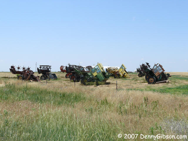
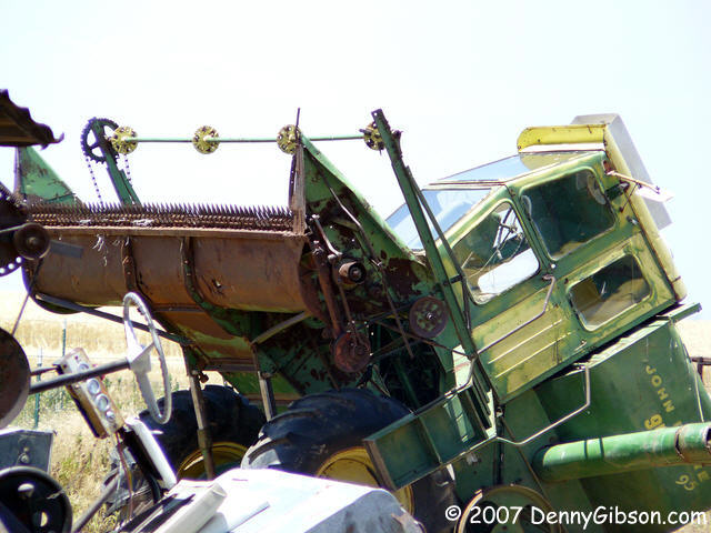
So here they are. Ten combines that Orville Ladehoff has buried on the north side of FM-1151 some twenty-five miles west of Claude, Texas. They are in three loose rows (3-5-2) and behind a barb-wire fence. Orville's looking for something a little more dignified than those other collections of half-buried machinery called ranches. Unlike the Bug & Cadillac Ranches, graffiti is not encouraged here and Orville prefers the name Combine City. Works for me. |
|
|
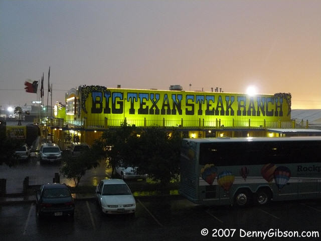

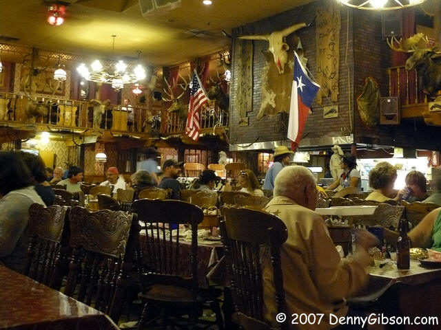
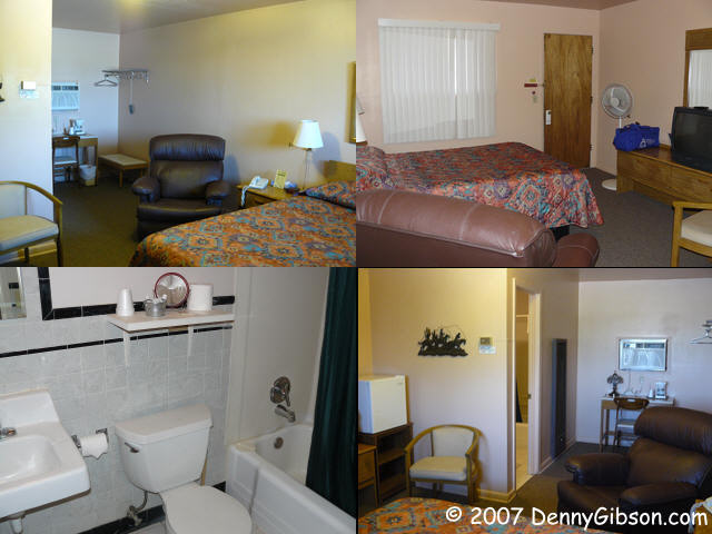
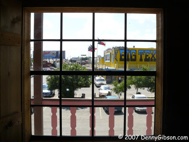 I had half considered Vega as a target for days end but, when Mike told
me, back at the cross, that the Vega Motel wasn't open, I decided on the
Big Texan instead
and headed a few miles south at the edge of Amarillo. The Big Texan isn't
on Sixty-Six but it once was and it's an Amarillo landmark often associated
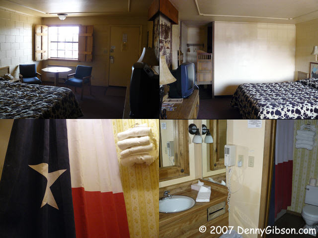
with the Mother Road despite its location. I got a
room with a view (of the
restaurant) and, after relaxing a bit and running a couple of errands,
walked over for dinner.
I had half considered Vega as a target for days end but, when Mike told
me, back at the cross, that the Vega Motel wasn't open, I decided on the
Big Texan instead
and headed a few miles south at the edge of Amarillo. The Big Texan isn't
on Sixty-Six but it once was and it's an Amarillo landmark often associated
with the Mother Road despite its location. I got a
room with a view (of the
restaurant) and, after relaxing a bit and running a couple of errands,
walked over for dinner.
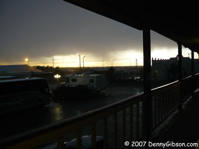
Weather reporters had been warning of severe weather and things started getting dark as I finished my meal. Quarter sized, golf ball sized, and even baseball sized hail was predicted by some and I understand that the golf ball prediction was met a little west of the city. What we got at the Big Texan was more like dime sized and you'd get a little change back on that with most of them. I thought one might plonk me on the head as I walked back to my room but they all missed me although a couple did bounce into my room as I stood there watching the storm. |
|
|
| [Prev] [Site Home] [Trip Home] [Contact] [Next] |