Connecting Connectors
Prev
Next


|
Day 9: September 4, 2011 Connecting Connectors |
Prev Next |
|
|
|

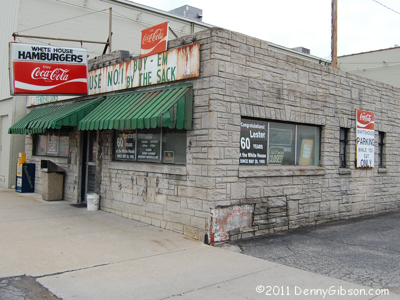 Confident that White House #1 would be open on Sunday morning, I headed
there for breakfast only to find the lights out and the doors locked. The
schedule painted on the window confirmed that
this was no fluke or Labor Day weekend exception. Yeah, I felt dumb. What
was I thinking? I'd checked my own "notes" in deciding it would
be open and I checked them again at the end of the day. A
schedule card that was in the
window in 2008 clearly indicates Sunday service. I felt less dumb but
still mourn my missed breakfast.
Confident that White House #1 would be open on Sunday morning, I headed
there for breakfast only to find the lights out and the doors locked. The
schedule painted on the window confirmed that
this was no fluke or Labor Day weekend exception. Yeah, I felt dumb. What
was I thinking? I'd checked my own "notes" in deciding it would
be open and I checked them again at the end of the day. A
schedule card that was in the
window in 2008 clearly indicates Sunday service. I felt less dumb but
still mourn my missed breakfast.
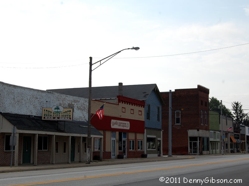
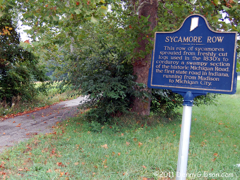
The other pictures are also of things I saw on that 2008 drive. One is Sycamore Row and the other the town of Kirklin. In 2008, Pat Bremer had intercepted me somewhere north of there in his Corvair. At Kirklin, he led me away from the Dixie Highway so I'd never driven this stretch of the road. Oh, goody. New stuff. |
|
|
 In retrospect, I think Pat may have said something like, "There's
nothing to see that way", as we departed Kirklin. If so, I apologize
for ever doubting. Between South Bend and Indianapolis, the Dixie Highway
Northern Connector follows the Michigan Road. I've seen other copies of
this sign but not this particular sign and it's the only thing I have to
post from my first drive on the DH between Kirklin and Indy.
In retrospect, I think Pat may have said something like, "There's
nothing to see that way", as we departed Kirklin. If so, I apologize
for ever doubting. Between South Bend and Indianapolis, the Dixie Highway
Northern Connector follows the Michigan Road. I've seen other copies of
this sign but not this particular sign and it's the only thing I have to
post from my first drive on the DH between Kirklin and Indy.
|
|
|

 I like Meridian Street. I drove it south into Monument Circle because I
was thinking that was the route of the Dixie Highway West Mainline. Some
after the fact map checking indicates that is wrong and that the DH didn't
move onto Meridian until it reached Washington Street south of the circle.
So none of these pictures are on the Dixie Highway but 1) I thought they
were when I took them, 2) they tell an interesting story, and 3) I like
Meridian Street.
I like Meridian Street. I drove it south into Monument Circle because I
was thinking that was the route of the Dixie Highway West Mainline. Some
after the fact map checking indicates that is wrong and that the DH didn't
move onto Meridian until it reached Washington Street south of the circle.
So none of these pictures are on the Dixie Highway but 1) I thought they
were when I took them, 2) they tell an interesting story, and 3) I like
Meridian Street.
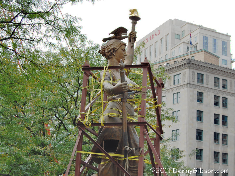
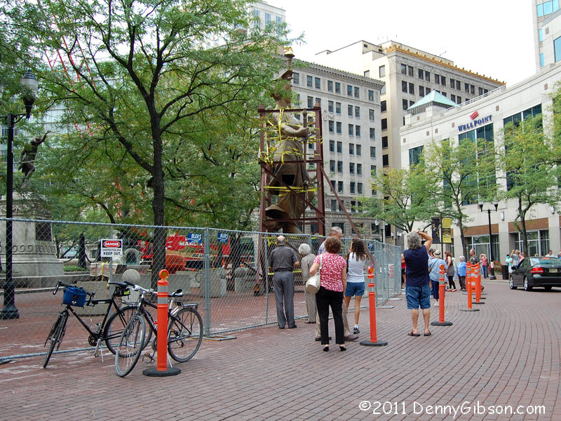
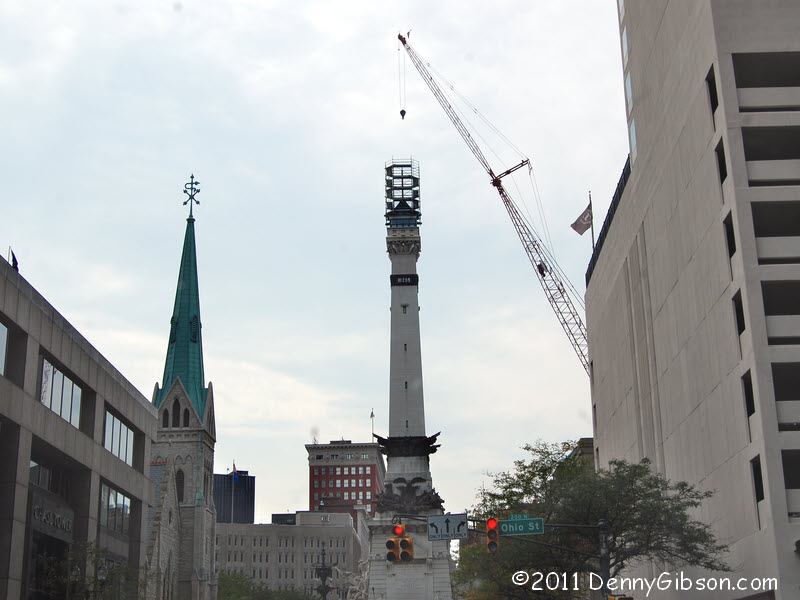
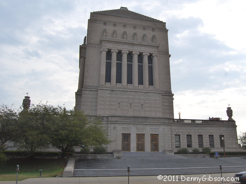
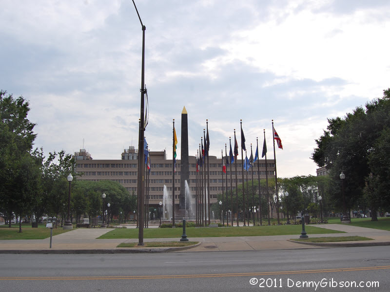
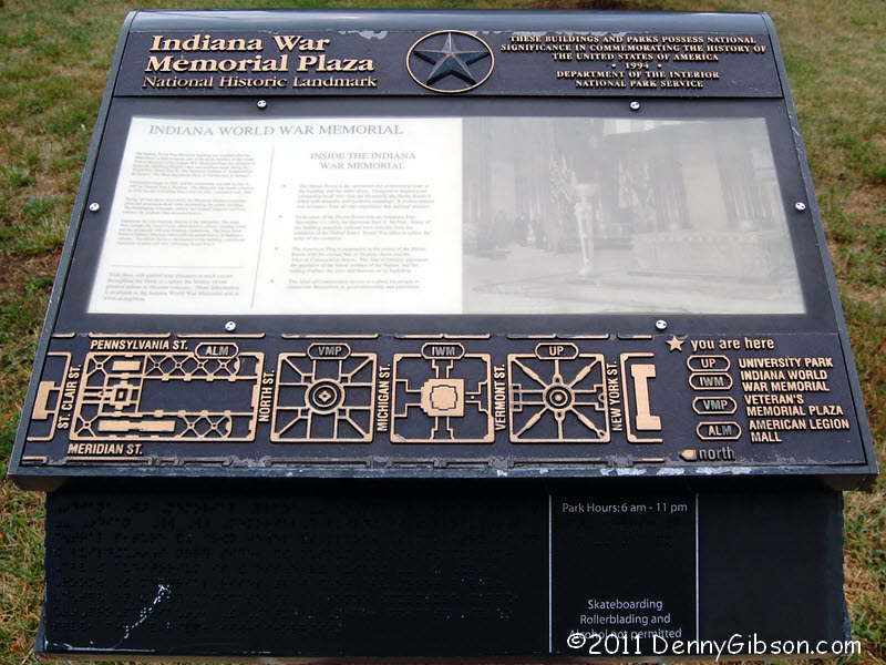
The first picture is of Veterans Memorial Plaza and the second is of the Indiana World War Memorial. Both were semi-drive-bys. I stopped but didn't actually park. If you do park, as I did later for just a few moments, there are some really heavy duty maps to help identify things. As I continued south on Meridian I became aware of a cage sort of thing on top of the Soldiers and Sailors Monument where a human figure was supposed to be. The circle itself was half filled with people all facing the same way and most with pointing cameras. It was rather easy to connect the caged figure on the street with the empty scaffolding atop the column. I've since learned that the figure, apparently named Victory, was removed for refurbishing on April 22 and will be hoisted back to its home at 6 AM Tuesday. She will spend the entire Labor Day weekend posing for pictures at ground level. ADDENDUM: Feb 17, 2015 - Looks like I was wrong about being wrong. As time goes on, it is becoming more and more apparent that there may never have been an official path thorough some cities for some named auto trails. I believe that might be true for the Dixie Highway through Indianapolis and I have found at least one guide (1916 Scarborough) that routes the Dixie to Meridian Street via Ohio Street. Ergo... |
|
|
 Before leaving Logansport, I sent email to a few friends in Indianapolis
letting them know I was heading that way. I heard back from roadie
Jim Grey just as I
reached the city and we hooked up for lunch. This was our first meeting
and the first time for either of us the eat at this restaurant.
Maxine's
Chicken and Waffles has been developing quite the reputation and Jim
has been wanting to try it. The location was nearly perfect and it turned
out that the food, service, and just about everything else was too. Jim is
in the early stages of plotting an Indiana Fried Chicken Tour with a
coworker and wanted to save the chicken until both of them could be there.
He went for the catfish of which he said, "It rocks." I was
delighted with my first encounter with chicken & waffles. One of the
fluffiest waffles plus three of the biggest and tastiest wings I've ever
seen. When the food arrived, I asked the waitress to take a picture of all four
of us: Jim, Denny, fish, and chicken. She struggled with finding and/or
fitting us into the viewfinder but at last declared the picture taken and
returned the camera. The flash hadn't flashed and no photo was recorded
but that didn't seem something worth pursuing. I'm using the distraction
of the waitress and camera as my excuse for failing to get a picture of my
lunch. It looked as good as it tasted and vice versa.
Before leaving Logansport, I sent email to a few friends in Indianapolis
letting them know I was heading that way. I heard back from roadie
Jim Grey just as I
reached the city and we hooked up for lunch. This was our first meeting
and the first time for either of us the eat at this restaurant.
Maxine's
Chicken and Waffles has been developing quite the reputation and Jim
has been wanting to try it. The location was nearly perfect and it turned
out that the food, service, and just about everything else was too. Jim is
in the early stages of plotting an Indiana Fried Chicken Tour with a
coworker and wanted to save the chicken until both of them could be there.
He went for the catfish of which he said, "It rocks." I was
delighted with my first encounter with chicken & waffles. One of the
fluffiest waffles plus three of the biggest and tastiest wings I've ever
seen. When the food arrived, I asked the waitress to take a picture of all four
of us: Jim, Denny, fish, and chicken. She struggled with finding and/or
fitting us into the viewfinder but at last declared the picture taken and
returned the camera. The flash hadn't flashed and no photo was recorded
but that didn't seem something worth pursuing. I'm using the distraction
of the waitress and camera as my excuse for failing to get a picture of my
lunch. It looked as good as it tasted and vice versa.
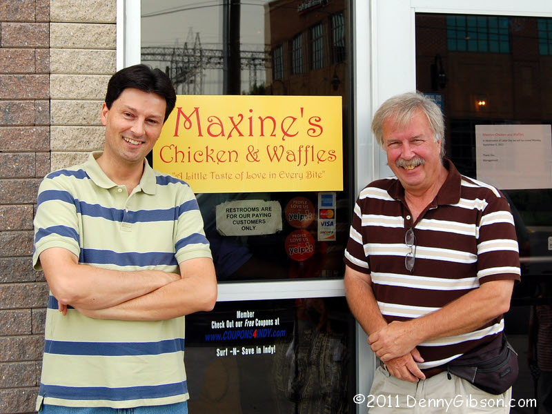
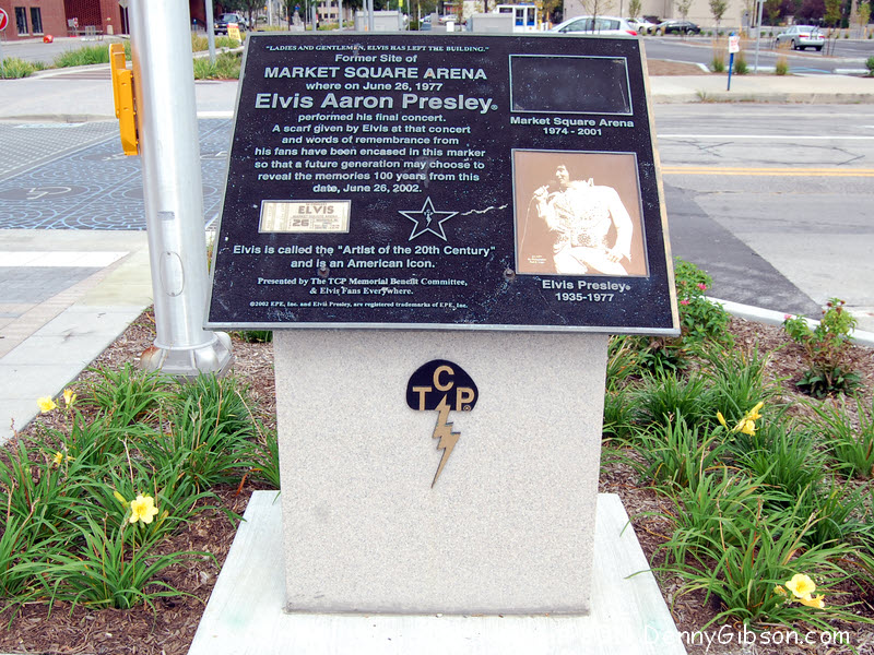
The photo shortage was lessened by asking a fellow waiting to be seated (This place was busy when we arrived and starting to overflow when we left.) to take our picture by the door. We were terribly disappointed to learn that rumors of free food for guys in striped shirts were entirely false but there was good news, too. Jim is one of the fellows behind the Historic Michigan Road organization and he told me the byway designation is now just waiting for the governor's signature. Way to go, Jim and Kurt. I was barely out of Maxine's parking lot when the GPS flashed an alert from the Roadside America add on. It seems that Market Square Arena once stood about a block away and there is a marker. It is not, however, a marker for the area itself. Instead, it commemorates an event far more important than any lifeless structure. |
|
|
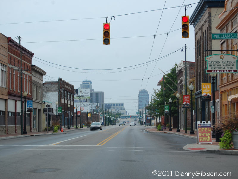
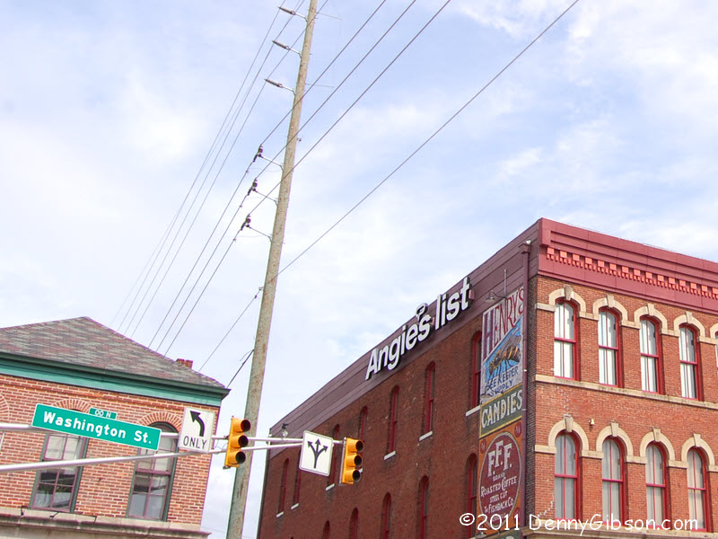 The Dixie Highway Midwestern Connector basically follows the National Old
Trails Road which basically followed the western portion of the Dayton
Cutoff of the National Road. Yes, I've driven it before but I drove it
again 'cause that's the way I roll. The first picture is near its western
end in Indianapolis where I was surprised to see the physical presence of
the cyber giant Angie's List. The second picture is near the other end
with downtown Dayton visible in the distance. The "OPEN ENTER
HERE" sign is pointing to the Wright Cycle Company which is part of
the Dayton Aviation
Heritage National Historical Park.
The Dixie Highway Midwestern Connector basically follows the National Old
Trails Road which basically followed the western portion of the Dayton
Cutoff of the National Road. Yes, I've driven it before but I drove it
again 'cause that's the way I roll. The first picture is near its western
end in Indianapolis where I was surprised to see the physical presence of
the cyber giant Angie's List. The second picture is near the other end
with downtown Dayton visible in the distance. The "OPEN ENTER
HERE" sign is pointing to the Wright Cycle Company which is part of
the Dayton Aviation
Heritage National Historical Park.
|
|
|
| [Prev] [Site Home] [Trip Home] [Contact] [Next] |