An Airy Plane Ride

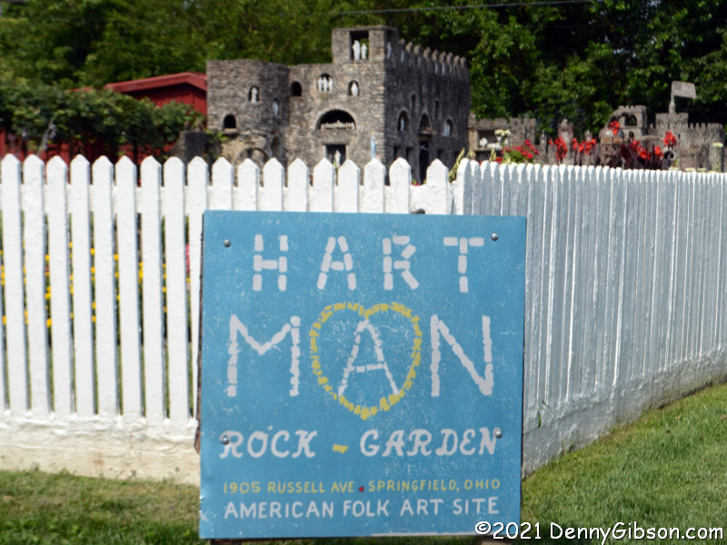
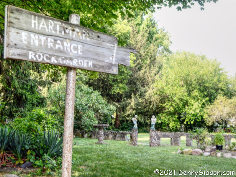
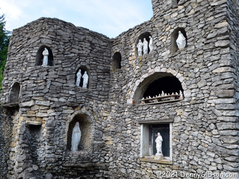
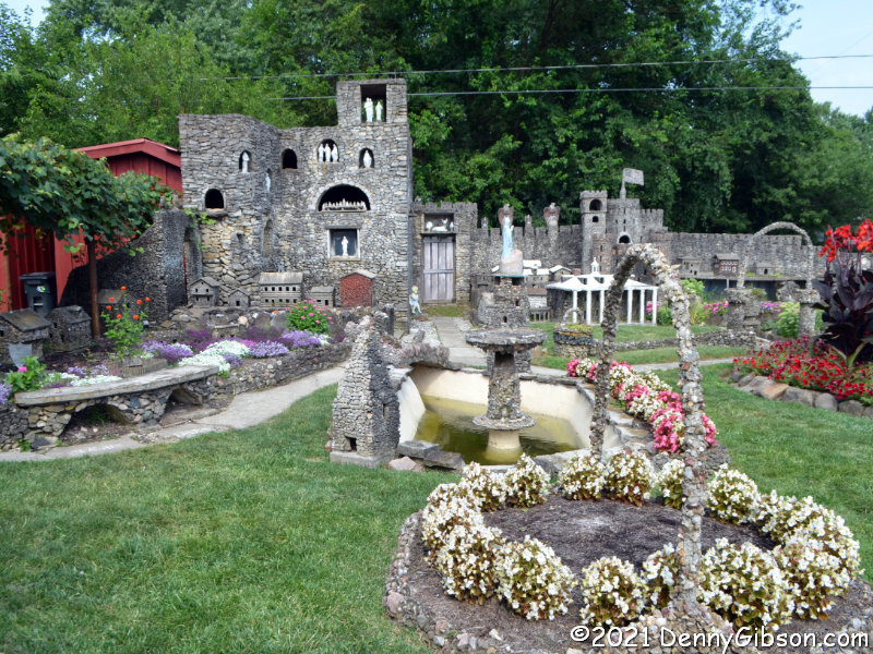
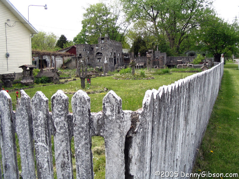
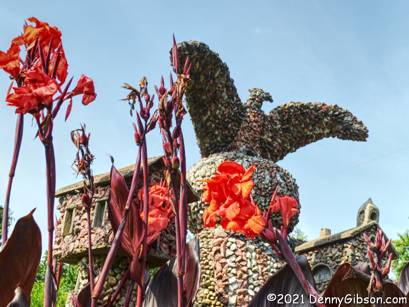
A couple of weeks ago I credited a blog post mentioned by another blog post with nudging me to revisit Hartman Rock Garden. However, it wasn’t the rock garden post that Jim Grey’s blog actually referenced and which prompted me to subscribe to Make the Journey Fun. It was this one: Deep Thoughts In Flight. It really struck a chord.

It was a chord that was just waiting to be struck. Flying in an open airplane had long been part of my own — not particularly deep — thoughts and blogger Brandi Betts’ July post, along with a couple of others about her airborne experiences with Goodfolk & O’Tymes Biplane Rides, finally prompted me to act on those thoughts.

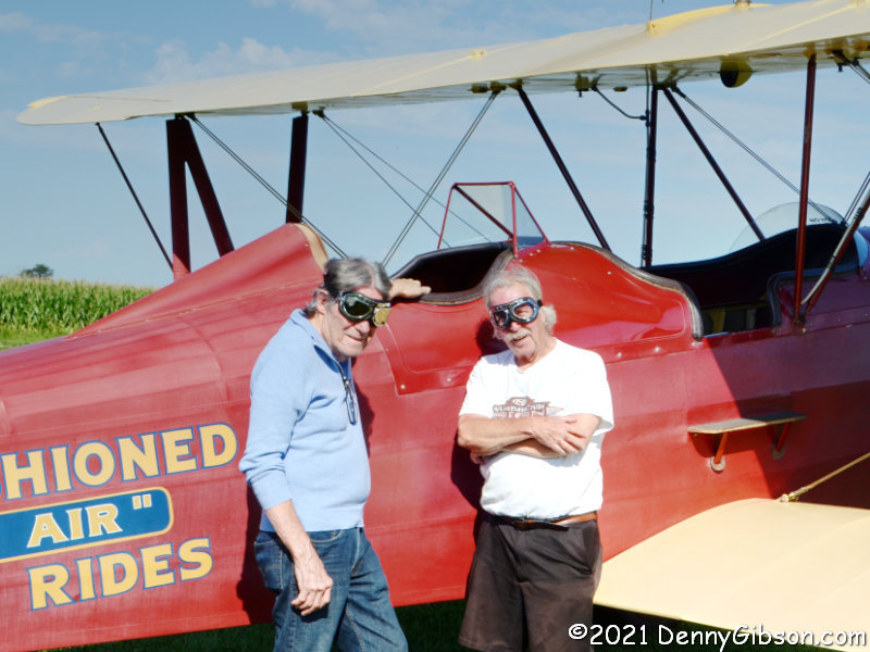
I spoke with owner/pilot Dewey Davenport by phone and made tentative plans for a flight on August 9. Clouds and the possibility of rain led us to postpone the outing, and when my friend John and I prepared to climb aboard on Tuesday, there was no doubt in our minds that the postponement was a good thing. The only clouds in the sky were the soft fluffy welcoming sort.

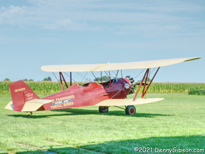
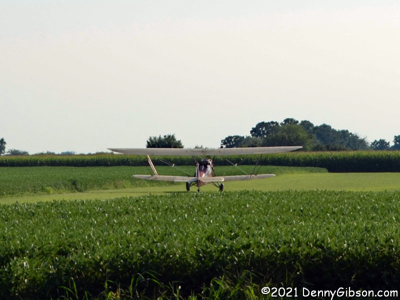
As probably everyone reading this knows, in the early days of flight, passengers sat in front of the pilot and this plane is definitely from those early days. The four-passenger (plus pilot) D-25 New Standard was built in 1930, less than twenty-seven years after Wilbur and Orville first left the ground in an aircraft with a passenger capacity of zero. During the in hangar preliminaries, Dewey gave us a rundown of the D-25 in general and of this one in particular. Although it spent some of its middle years as a cropduster, it had been built specifically for barnstorming which is precisely the role it has returned to. A photo of this very plane appeared in National Geographic showing its use along the Snake River in one of the very first air rescue operations — in 1935!.

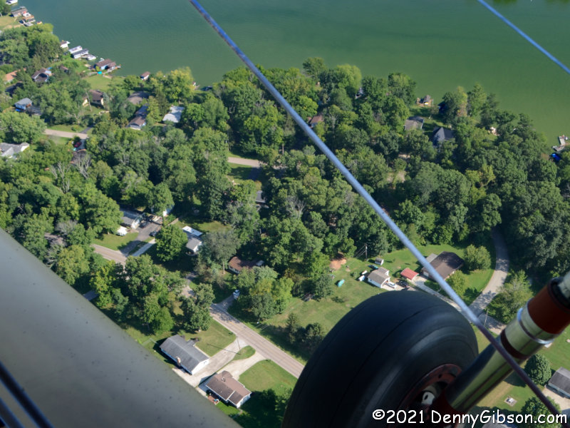
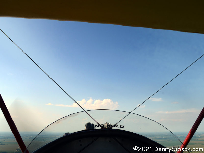
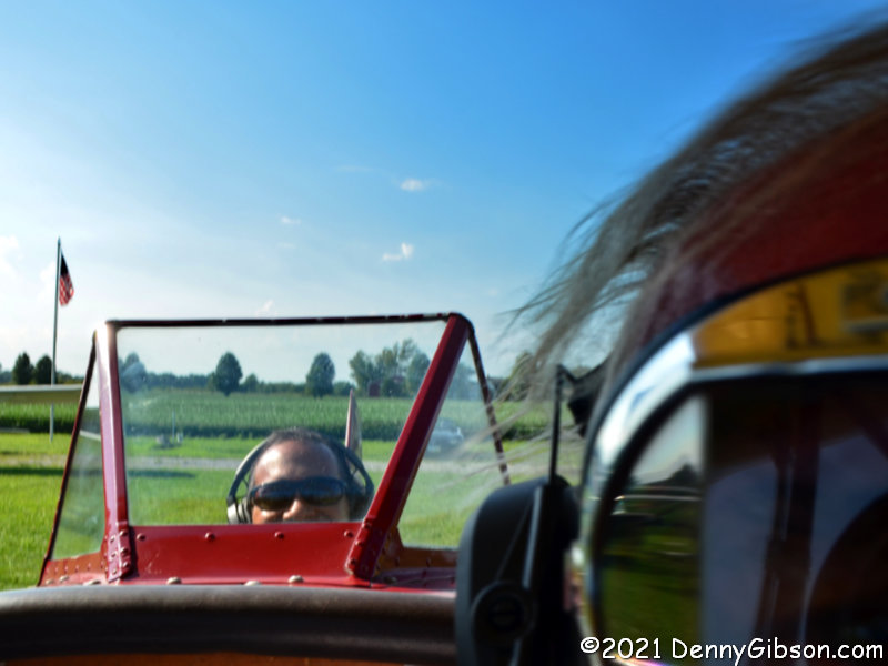
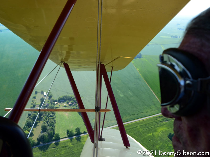
As we climbed into the sky, I, feeling we would likely need it later, kept an eye on our left landing gear. I assume John was similarly watching over the right side gear although I did not verify that. Conversation with protective earmuffs in place is challenging. I have flown in small airplanes in the past but never with the delightful in-your-face wind and noise of an open cockpit. I suppose it might become noticeably less delightful on a multi-hour flight to the coast although I’m not entirely sure of that. Experiencing flight in exactly the same manner that it was experienced close to a couple of decades before I was born was pretty darned cool and not a little exhilarating. Even though the overhead wing meant we passengers were traveling comfortably in the shade, the bright sun did enable me to take a long-distance selfie.

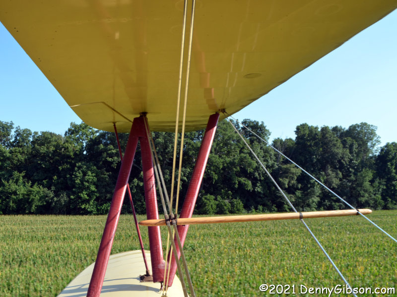
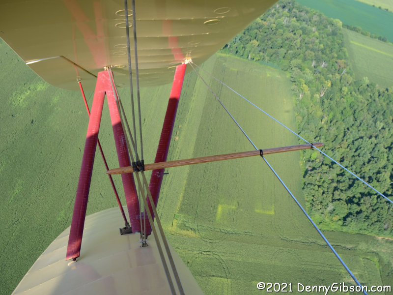
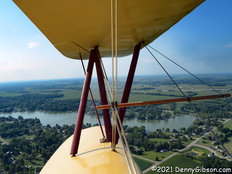
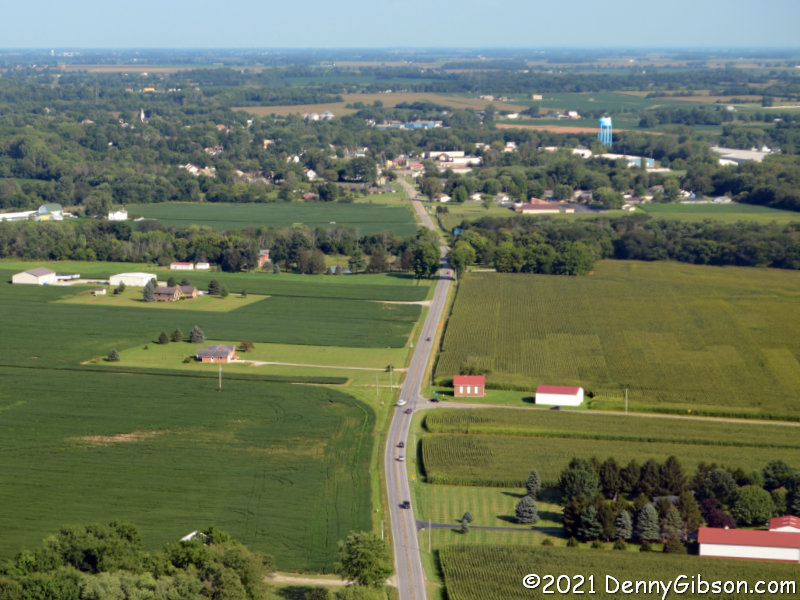
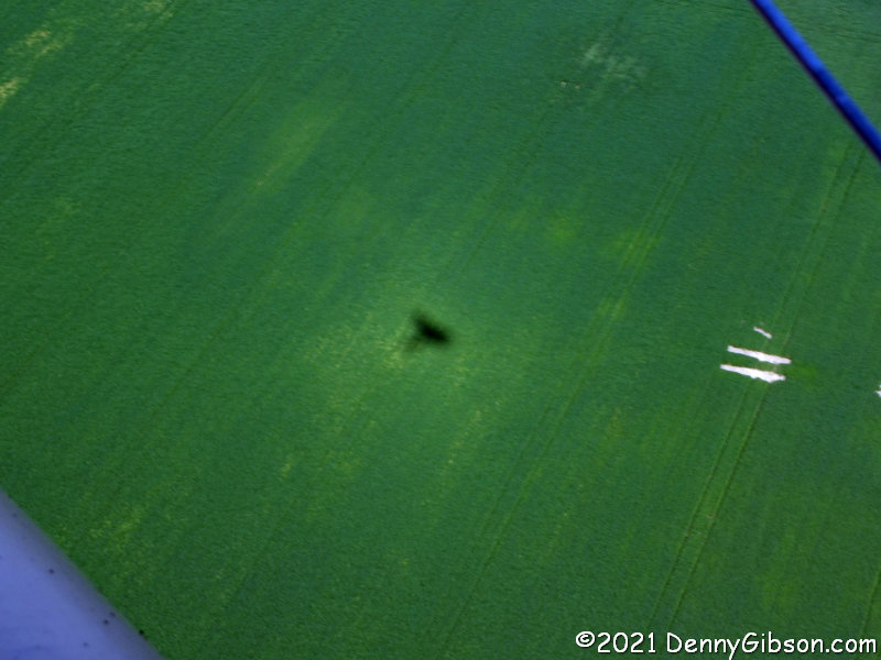
The view that an open aircraft provides is clearly unbeatable. In addition, Dewey made sure we experienced some of the unique non-visual sensations available as well. There was nothing remotely dangerous, of course, but we were treated to some climbs and dips that delivered that hint of weightlessness found on really good roller coasters. And there were some fairly hard banks. First to the right, so I could look straight at the ground right past John. Then to the left, so I could look straight at the ground right past nothing. That third picture might look like we are parked on the ground but nope. Dewey was just giving us a feel for what crop-dusting might have been like.

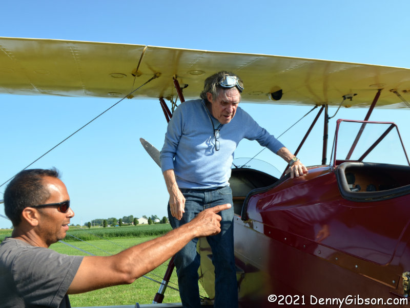
After we actually had landed, I exited ahead of John and turned around just as Dewey answered his question about where the nearest cornfield was.


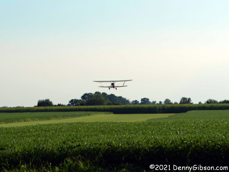
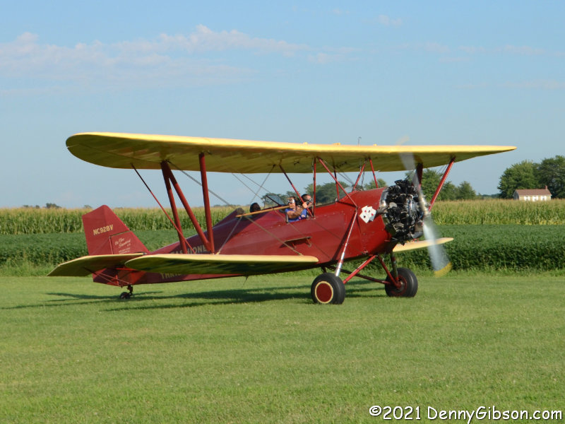
Another flight was scheduled shortly after ours, and we stuck around to watch it take off. It was a very short taxi back to the runway then a revving of the radial engine started the airplane speeding — in a leisurely manner — over the grass to break free — also in a leisurely manner — from Earth’s surface. Dewey is almost always successful in his goal of making sure every customer has a great experience. He definitely works at it. The only time someone has been unhappy was when a flight had to be canceled due to darkness. Not only do people leave feeling happy, a goodly number no doubt leave feeling envious of Dewey’s “office”. John and I sure did.


I don’t have a “favorite blogs” list, but if I did Make the Journey Fun would almost certainly be on it. Brandi Betts visits some of the same sorts of places I visit and writes about some of the same sorts of things I write about. She does it more frequently (often daily), also writes about some things I do not (e.g., her cat), and has the occasional deep thought post more often than I do (which is pretty much never). But even if she had not turned me onto a wonderful keeper of bi-planes or reminded me of a delightful rock garden I’d still applaud her blog simply because of the name and the tagline. And that’s some pretty deep thought for me, eh? 

Music Hall Inside and Out

I recall that at some point during the COVID-19 “shutdown”, outside tours of Cincinnati’s Music Hall became available and I had every intention of joining one. I do not recall why I didn’t. I finally made it on Saturday but by then, inside tours were also available so I did one of those on Friday. I’m no stranger to the 144-year-old building and even posted some 100% layman-type commentary on the place before and after its recent renovation: A Pre-Refurb Peek at Music Hall and A Post-Refurb Peek at Music Hall. But what little I did know about the building came purely from attending events there so I learned plenty from both tours.

Much of Friday’s tour was through public spaces I was fairly familiar with but which I’d never seen without a crowd of concertgoers. The statue of Reuben R. Springer is in the main lobby. Springer donated the majority of the money to construct the Samuel Hannaford designed building that replaced a tin-roofed wooden structure on the site. During the 2016-17 renovation, the solid wood doors across the front of the building were replaced by glass doors that really brightened up the lobby. Two of the original doors now stand behind each of the two bars in the corners of the lobby.

The main performance space is named Springer Auditorium and I’ve been inside it quite a few times. That includes once since the big renovation so I was aware of improvements like the wider seats and overhead acoustic panels. I was not, as a certain cinematic scientist might say, shivering with anticipation when we entered but maybe I should have been. I knew that the 1,500-pound Czechoslovakian chandelier was lowered and cleaned on a regular basis and was even vaguely aware that it happened every two years but I had no idea that one of those cleanings was currently in progress. Seeing all that crystal at eye level with the ceiling images unblocked was probably the day’s personal highlight for me.

We did get into some non-public spaces I’d never seen before. One of these was the huge backstage area with a glimpse of the main stage through a narrow opening. Another was the north hall which was originally built for industrial exhibitions but which became an athletic venue at some point. It was here that Ezzard Charles won many of his fights on the way to becoming World Heavyweight Champion and where the Cincinnati Bearcats played basketball in the 1940s. Cincinnati Gardens effectively took over the job of hosting Cincinnati’s athletic events when it opened in 1949. This is where I took the picture of the handpainted Music Hall that opens this article.

Friday’s last stop was the upper floor of the south hall. The south hall had been built as a place for agricultural exhibits. With its glass roof, it functioned as the city’s horticultural showplace until Krohn  Conservatory opened in 1933. Since then, it has served as a nightclub and dance hall in various forms and today is often rented out for private functions. I have been here a few times but only when it was jam-packed with people.

There were, of course, no non-public spaces on Saturday’s outside tour and I don’t believe I actually saw anything that I had not seen before. I did, however, learn quite a bit and now see some things differently. I know I’ve heard the architectural style described and may have even heard some form of the name our guide used; High Victorian Gothic Revival. But I don’t recall ever hearing the idiom he shared: “stripes and spikes”. He attributed this to an architecture critic of the day and it certainly seems to fit.

The south hall is marked with leaves and flowers to match its agricultural purpose while the north hall’s industrial connection is indicated by gears and mallets. Musical lyres adorn the central building.

The main building displays its year of completion if you can sort the digits into the right sequence. The two side buildings were completed during the following year. The fronts of all three were constructed with glazed bricks brought from Philadelphia and Zanesville. Some of these were then black coated on site. The rear portion of the buildings used less expensive local bricks and some additional money may have been saved by not paying someone to shuffle the build date.


Music Hall is close to downtown Cincinnati and I used the tours as an excuse to eat at a couple of favorites I don’t get to all that often. Friday’s tour was in the afternoon and I stopped by Camp Washington Chili on the way home but took no pictures. Saturday’s tour was in the morning and I headed to the Anchor Grill for breakfast. I did not intend to take pictures there either, but a banner in the parking lot changed my mind. Anchor Grill survived the worst of the pandemic on carryout so I checked before I went, and was happy to see they were now allowing dining-in. Apparently, they’ve been doing it since May, and that’s when the actual 75th anniversary was, too. I really should have been paying attention.

In my experience, the Band Box isn’t played much but almost as soon as I got my order in today, the curtain opened and the music began. It was still going when I left with the animated dance orchestra performing a non-stop medley of brokenhearted country love songs. I thought that was really special. And eating in restaurants older than me two days in a row is pretty special too.

The Berlin Masterpieces in Cincinnati

This post’s title is a take-off of the title of an exhibit at the Cincinnati Art Museum the full and accurate title of which is Paintings, Politics and the Monuments Men: The Berlin Masterpieces in America. At the heart of the exhibit is the story of a wildly popular, though somewhat controversial,1948 tour of paintings with its own title: Masterpieces from the Berlin Museums. The tour did not reach Cincinnati although two of the fourteen cities it did reach, Cleveland and Toledo, were in Ohio and there is a major Cincinnati connection.

The picture of General Eisenhour looking over some of the paintings that the Nazis had hidden away is at the entrance to the exhibit. On the other side of the wall it is mounted on, there is a timeline of the Nazis’ rise and fall that ends with the Masterpieces from the Berlin Museums tour. Two items from late 1943 are “Allies invade Italy”, in September, and “Monuments, Fine Art, and Archives section (Monuments Men) of the U.S. Army is established”, in December. The Monuments Men (the subject and title of a 2014 movie) set out to locate and protect artworks at risk of being destroyed by the Nazis.

Thousands of items were located, some in a large salt mine, and brought together at Wiesbaden, Germany. This is where the Cincinnati connection comes in. The director of the Wiesbaden Central Collecting Point was Cincinnatian Walter I. Farmer. By itself, his work in documenting pieces of art and preparing them for return to their owners would have been noteworthy but there was something more.

When he became aware of plans to ship a large number of paintings to the U.S. for safekeeping, Farmer organized thirty-two Monuments Men to produce the Wiesbaden Manifesto which protested what Farmer feared was “spoils of war” type treatment of the European treasures. Smithsonian Magazine calls this “the only act of protest by Army officers against their orders during the entirety of the Second World War”. Although it was eventually published, the manifesto was initially suppressed by Farmer’s superiors. The paintings were shipped to the National Gallery in Washington, DC, and placed in storage. As plans formed to return the paintings to Germany, it was decided to put them on display before their departure. An exhibit at the National Gallery was so popular that the U.S. Congress took notice and actually legislated the tour of thirteen additional museums. All 202 paintings were returned to Germany at the conclusion of the tour. 

Photos of “The Berlin 202” are displayed on a wall near the center of the exhibition. Four of the actual paintings, on loan from the State Museums of Berlin, are on display. The exhibit is fleshed out with other paintings in CAM’s possession by some of the artists contained in the 202. Paintings, Politics and the Monuments Men: The Berlin Masterpieces in America runs through October 3, 2021.

Third Time Was Charming

I finally got myself back to the garden. On Friday, I made my third visit to the Hartman Rock Garden in Springfield, OH. It took two nudges. One came from that source-of-many-things, Jim Grey’s blog. Jim makes a weekly “Recommended Reading” post that I always scan but confess to not clicking as many links in it as I used to. That’s no reflection on the quality of Jim’s recommendation but a combination of his (and his readers’) increased interest in film cameras and my decreased unallocated reading time. I clicked through on one of his July 24th recommendations and got hooked on a blog that I fully expect to quickly lead to at least one more post here along with a fuller story. I subscribed to the RSS feed which instantly brought me several recent articles, including one about a visit to the Hartman Rock Garden. That article is here. Thanks, Jim and Brandi.

The second nudge came from an issue of Echoes, the Ohio History Connection magazine, which I had received but not yet read. Inside, a six-page article titled “Channeling a Creative Spirit” told of Ben Hartman’s creative response to finding himself jobless in the 1930s during the Great Depression. I don’t credit that pair of nudges with anything magical or supernatural but I do credit them with making me think of Springfield when an idle Friday and an open blog slot came along. 

The garden started with the cement fish pond in the middle of the first photo at right. Ben was an accomplished molder at the Springfield Machine Tool Company when the depression hit. He was laid off in 1932 at age 48 and built the pond to fill his suddenly empty days. He moved on from the pond to figures and structures made of stones and other found items. Once he started building, he never stopped. His creations came in all sizes. These pictures are of some of the largest. At fourteen feet, the cathedral at the back corner is the garden’s tallest structure. A model of Da Vinci’s “The Last Supper” fills one of its many niches. The castle beside it is only a couple of feet shorter. It is believed to be based on a picture on a postcard that his wife, Mary, received.

Ben returned to the foundry in 1939 but died of silicosis just five years later. Mary maintained the garden until her death in 1997. What followed was about ten years of neglect. The deterioration was nearing its peak when I made my first visit in 2005. The picture at left is from that visit. The deterioration ended just a few years later when preservation-minded Kohler Foundation purchased the property in 2008. Following restoration, ownership of the garden was transferred to Friends of the Hartman Rock Garden, and a grand reopening was celebrated in June of 2010.

Two of the garden’s most iconic structures are the Tree of Life and the Hart(heart)MAN logo.

Today the Tree of Life was somewhat obscured — quite beautifully — by tall canna lilies. Here it is on my second visit in 2011. The cactus-like structure promotes the three things that Ben thought important in life. One arm holds a school and the other a church. In the center, the shield and eagle represent country. Ben estimated that this structure contains approximately 20,000 stones.

This is probably the most underappreciated structure in the whole garden. That’s because it looks exactly like an ordinary wooden picket fence but it isn’t. The entire fence — all 410 pickets — is concrete and Ben said it was one of the most difficult of the garden’s structures to build.

The structures in the garden look every bit as good as they did immediately following Kohler’s restoration and the landscaping looks even better. Those “friends” are doing a wonderful job. In addition to maintaining and enhancing the garden, they have produced an excellent “Guide Book and Map” that is available near the entrance. There is also a “Kids Tour” booklet available on site plus it and both pre- and post-tour worksheets can be downloaded. Admission is free but there is a donation box and this is certainly a place that deserves your support if you are able.


You may have noticed that the Hartman Rock Garden was not the primary reason I was in Springfield in either 2005 or 2011. Since I included some then-and-now garden pictures, I’m including a then-and-now of my reason for the 2011 trip. The 2005 trip was to see a temporary exhibit so there is no then-and-now. The 2011 outing was to check on the progress of the Ohio Madonna of the Trail monument’s move from its location at Snyder Park to downtown Springfield. In 2011 she was still at Snyder Park but was all packed and ready to go. I’ve since photographed her several times in her new home and today I did it again.

Gimme Shelter — Umbrellas in Batesville

I think I was hooked the instant I saw an article about the Umbrella Sky Project coming to Batesville, IN. Actually, the project had already arrived and the article (I believe it was this one.) contained several photos of the colorful canopy. I was immediately reminded of a photo I had taken of a much smaller arrangement of umbrellas in a store in Natchitoches, LA. I told myself I would attend at the earliest opportunity, and I did. That opportunity came Monday.

There were some slight similarities between that Natchitoches photo and some of Monday’s photos, but the scale of the installation and the use of solid color umbrellas meant there were even more differences. The physical scale of the installation is impressive but the scale of its reach is probably more so. The concept originated in Agueda, Portugal, in 2011, and there have been installations in places such as Paris, France, and Stockholm, Sweden, as well as at Dollywood in Tennessee.

Magic, shows, musical performances, and other events have taken place under or near the Umbrella Sky in Batesville and more are scheduled throughout the installation’s stay which ends November 9. I halfheartedly tried to time my visit to catch some event but ended up driving there more or less on the spur of the moment. Of course, I might return.

This last picture is actually the very first one I took when I approached the installation. I had no intention of using it and only decided to do so halfway through writing this article. It’s titled Children of Peace and described on a pedestal-mounted plaque. As I tossed the words “umbrella” and “parasol” around fishing for a title for this post, the word “shelter” tumbled in and that led to the title of the Rolling Stone’s song from 1969. I liked the sound of the title but the lyrics just did not seem to fit that colorful “sky”. Then I remembered this sculpture with its hope of spinning “in a brighter direction”, and heard some of that same hope in the song’s ending lyrics.

I tell you love, sister
It’s just a kiss away
Kiss away, kiss away

Majestic Possibilities

This is the Showboat Majestic‘s fifth appearance in this blog. The first (Majestic Still) was in 2013 when I attended one of Cincinnati Landmark Productions’ final round of performances aboard her. The second and third (Much Miscellany and On the Waterfront) both involved Cincinnati Film Festival events onboard the otherwise idled boat in 2015. In the spring of 2019, she departed Cincinnati’s public landing after being sold to Moyer Winery near Manchester, Ohio. I spotted her at her new location when I was on the way home from somewhere else (Portsmouth Road Meet) and snapped a picture. That was in May and a month later the winery burned to the ground. The thriving business that the floating theater had been purchased to augment was no more.

On Wednesday the 17th, the Majestic moved to the town of New Richmond where she will stay for at least ten years. There’s a good report, including video, of the arrival here. There is currently no schedule for events involving the boat, and work remains to get her comfortable and accessible, but there is no doubt she will be a very nice addition to an already attractive town.

New Richmond is much closer to me than Manchester. It is home to the world’s only cardboard boat museum and annual cardboard boat race. It’s a place I get to fairly often in the summer and occasionally in the winter. I headed there last Sunday to get some pictures of the new arrival and eat breakfast at the Front Street Cafe. Then I headed upriver to cross at Maysville, head back toward home on the Kentucky side, and grab this picture on the way.

Purple Trusses Majesty

This isn’t the first year for a Christmas display on the Purple People Bridge but it is the first year I’ve taken notice. Maybe that’s because more people have been posting pictures of it on social media, or maybe it’s because I’m sitting at home paying more attention, or maybe it’s because the display has received a little more publicity because it almost didn’t happen. The privately-owned bridge is normally home to a variety of events throughout the year but that was not the case in COVID riddled 2020. There was simp[y no money in the budget of the nonprofit Newport Southbank Bridge Company for lighting the bridge this year, but local companies, led by realtor North American Properties, stepped in to assure that there will be lights. The 25-foot tree placed at the bridge’s south end by the Wish Tree Program is covered with gift suggestions for people in need.

I arrived at the Kentucky end of the bridge a little before sunset and walked across it to Ohio. Note that the state line is a lot closer to Ohio than it is to Kentucky. It is the low-water mark on the northern bank — as it existed in 1792. When “love locks”, closed by couples before tossing the keys in the river, became a problem around 2017, they were removed from the actual bridge and a special area designated. I presume that even the special area has to be cleaned up occasionally. The middle picture is of the Big Mac Bridge which carries I-471 and is officially named the Daniel Carter Beard Bridge. The supports in the foreground of that picture once carried railroad tracks. They can be better seen here. The third picture was taken from the Cincinnati access ramp looking back at the bridge.

As the light faded, I headed back toward Kentucky. With the change in lighting, the people on the bridge also begin th change. It had been mostly people jogging or biking for exercise and workers on a foot-powered interstate commute. Now small groups, including some obvious families, began to appear to take in the lights.

When darkness came, the bridge began to take on that “infinity room” look I’d seen in pictures others had shared online. Somewhere near the middle, I leaned over the railing to grab a shot of the big tree in Newport.

Back on the Kentucky shore, I stepped off to the side for a view of the city across the river before taking a parting shot of the Wish Tree and heading home. The display is free and it only cost me $3 to park in the garage next to the bridge. The lights will be lit each night through January 15.


What was originally called the Newport Cincinnati Bridge opened in 1872 as a railroad only bridge. Over the years, it was widened, had decks added, and for a long time served automobiles, trains, and pedestrians. It lost the trains in 1987, became a people bridge in 2001, and became purple in 2006. In addition to being painted purple, the bridge had stairs and railings added to allow people to walk along the top of its trusses for a fee. They’re still there.

Sadly for the promoter, there usually wasn’t all that much to look at, and, even when there was, the improved view from a maximum of maybe 140 feet above the free-to-walk deck did not seem worth the fee which hovered in the $30-$40 range. These pictures were taken during Cincinnati’s last Tall Stacks Festival when the riverfront was full of boats. That gave climbers something to look at and the idea was new enough to seem attractive. I’m fairly certain those few days in October 2006 were the busiest ever for the climbing operation which closed less than a year later. 

A Pair of Parks and a Pint

Parks are pretty good places to go when one of your goals is not getting close to people, and Friday’s extra fine weather made doing something outdoors all but mandatory. I had only recently heard of Chrisholm MetroPark and the fact that it was fairly close to another park I’d been thinking of revisiting made it the choice for my first stop of the day. The opening photo was taken from the east end of the full-width porch on the front of the Augspurger House.

In normal times, tours of the Augspurger House are given on certain days but that has been curtailed by COVID-19. There was no apparent activity at Rosemont Barn, either. In fact, the only non-visitor I saw was a fellow doing some mowing in a field on the far side of the barn.

This turned out to be the most interesting building in the park today, and I think it would be quite interesting even with house tours and a critter filled barn as competition. The interesting part is that, as the sign explains, it is one of thousands built by the Works Progress Administration. Existing outhouses were often quite shabby with poor drainage. For the cost of materials, the WPA would construct a properly designed sanitary outhouse. The WPA was the brainchild of Franklin Roosevelt and his wife was the major proponent of this effort to improve sanitation in rural areas. The tidy tiny buildings became known as Eleanors.

That’s just one of the things I learned today. I also learned a new word. The park’s real restrooms are next to the restored (but unused) Eleanor. They are currently closed and I didn’t even get a picture of the building but I did get a picture of a sign describing them and teaching me a new word. Described as “Butler County’s First Green Restroom[s]”, the composting restrooms deal with “humanure”.

Half of the visitors I saw in the park were at this very cool Playscape. On the way out, I drove by a couple walking their dog, and here I encountered a mom and daughter having a great time on the rustic-styled playground equipment. They do appear as two dots in the background of the second picture, but I really tried avoiding them in my pictures which meant waiting to photograph the tractor while mom was in the wagon being pulled “very fast”.

Pyramid Hill Sculpture Park is a little more than eight crow miles from Chrisholm MetroPark. My most recent visit was last December for the Holiday Lights. Today was a reminder that I need to come in the daytime more often and I probably need to pack a lunch. I also need to schedule better so that I am here when the indoor Ancient Sculpture Museum is open.

I started off misreading the map so was sort of walking around randomly for a bit. That’s not a problem, of course, as there are sculptures and scenic backdrops everywhere. These photos were chosen about as randomly as my path. The first is of Greg Loring’s Life’s Twists and Turns. The second is Age of Stone by John Isherwood, and the third is George Sugarman’s Garden of Sculpture.

Harry T. Wilkes, the man responsible for creating the park, built and lived in this pyramid topped home that gives the park its name. His 2014 obituary describes him well, and John Leon’s lifesize sculpture gives him something of a continuing presence in the park.

With more than a hundred sculptures displayed on 300+ acres, there is no shortage of things to look at or photograph. I did not photograph everything I saw but I came away with enough photos to overflow this blog post and probably a couple more. In fact, I took enough photos of just this one piece to bore most people. I’m wrapping up my visit with just three views of Sam McKinney’s Wherefore Art Thou with Romeo and Juliet reaching desperately to touch each other through the black granite and family conflicts that separate them.

This was my first COVID era visit to Municipal Brew Works which sits between the two parks in downtown Hamilton. I ordered the 1791 Oktoberfest from mask-wearing servers inside then parked myself at an outside table far from the few other afternoon drinkers. I can’t think of a better way to finish up a temperature perfect day filled with history, art, and sunshine. 

Dam Dents Revisited

I know I can’t do this forever, but I let the Facebook crowd steer me to another blog post this week. This one is somewhat different in that it doesn’t involve something new to me but some things I’d seen multiple times in the past that I was due for a refresher on. Back in 2006, I did Oddment pages on two dams that altered the path of the National Road north of Dayton, Ohio. Those pages are here, for the Taylorsville Dam, and here, for the Englewood Dam. The next year, I wrote an article for American Road Magazine (Vol V Num 3) that talked about both dams. The name of this post comes from the name of that article.

The first photo at left shows the easternmost edge of the easternmost dent. The road runs south for about a mile and a half before turning west to cross the mile-long dam then turning north to rejoin the original route. The dam is shown in the opening photo, which some will recognize as my attempt to reproduce George R. Stewart’s Photo #27 from 1953’s US 40: Cross-Section of the United States of America. Stewart’s photo and my “update” concentrate on the spillway and the bridge that crosses it. More of the massive earthen dam can be seen in the picture at left. The dams were completed in 1922 in response to the horrific 1913 flood. At that time, this was still known as the National Road. It would become US-40 in 1926. The 1953 and 2020 photos show some differences in the bridge itself due to a 1979 rehabilitation. The National Old Trails Road, a continent crossing named auto trail that existed from 1912 to 1926 never crossed these dams since the NOTR followed the “Dayton Cutoff” south through Dayton and Eaton.

There is a small paved area at the east end of the Taylorsville Dam where I parked to photograph it. On the west end, there is an actual park area with considerably more parking space and several informative signs including one from the Ohio National Road Association on Tadmor and Taylorsville. A section of the extensive Miami Vally Trails system passes through here and makes it easy to get to the former location of the town of Tadmor about 1.3 miles away.

The first of these pictures was taken looking back to the south after I’d strolled beyond Tadmor. I have been to the site since the dual purpose plaque (readable here and here) was placed but there are more labeled posts than I remember. Another difference is the rather impenetrable growth between the path and the river. There is a narrow path next to the previously pictured Tadmor sign that leads directly to the abutments of a short bridge that crossed the canal. Because of the growth and my aging sense of adventure, I did not go beyond this today as I did in 2006. The third picture shows a wall of the canal sluice gate with the canal bridge abutments in the foreground.

The rules called for the National Road to follow a straight line to the capital city Columbus with no grade greater than 10%. At Tadmor, following both of these rules in the early 19th century was impossible and it was the straight-line rule that lost. The road turned to the south on the west bank of the Great Miami and curved around a large hill. The grade, though not as bad as climbing the hill, still gave westbound travelers and their animals quite a workout. A spring near the top was certainly a welcome sight. The spring can be reached by heading east a bit where US 40 picks up the original path of the National Road. Although it’s not easy getting a clear view of the spring-fed waterfall, it is pretty easy imagining how refreshing it was to a team of horses dragging a Conestoga wagon up from the riverbank. A less blown-out version of the plaque is here.

An intersection between the dents has a legitimate claim on the Crossroads of America. In the days before US Numbered Highways, the National Road and the Dixie Highway crossed here. With the coming of numbers, the crossing routes became US-40 and US-25. A fair amount of traffic still passes through the intersection today though not nearly as much as through the nearby intersections of the successors to these routes, I-75 and I-70. The memorial bench and explanatory sign are just west of the intersection. A detail lifted from the sign explains a detail lifted from the photo of the intersection.

Continuing west, I came to the beginning of the second dent. Behind those trees on the right is a bypassed earlier curve which I slipped onto for a photograph. The entrance to the eastern portion of Engelwood Metropark is right at the eastern end of the dam. There is parking space for several cars and that is where I paused to photograph the dam and explanatory sign.

The road through the park is one-way which requires the former National Road, now called Patty Road, to be driven from west to east. Since all my other driving in this post has been east to west, that’s the sequence in which I’ve arranged these photos. The little bridge doesn’t look particularly historic when driving over it but the underside is a different story. The second picture shows the bridge from the north side and there’s a view from the south here. A sign that once stood near the bridge has gone missing so I’ve included a photo of it from 2006. The third photo shows where the National Road once continued westward. I walked down it in 2006 but did not today. There really isn’t much to see as a water-filled borrow pit prevents reaching the river.

This is on the west side of the Stillwater River in the smaller portion of Engelwood Metropark. I’ve been in the park before but did not do much exploring. Today I walked an abandoned section of the National Road down to the river. I’ve heard, and have even told others, that there are pieces of bridge abutments along the river. That might be true, but I didn’t see any today. I also didn’t see an explanatory sign mentioned in a Facebook post by William Flood, author of the upcoming Driving the National Road & Route 40 in Ohio: Then and Now. Further online discussion indicated that it might have gone missing from this wooden post. Not finding the sign certainly wasn’t an issue since looking for it is what led me to the riverside and that’s a good thing.


Yes, I had breakfast. The Mell-O-Dee Restaurant isn’t exactly on the National Road, but about two miles to the south where it’s been since 1965. COVID-19 precautions include a closed counter, plexiglass dividers between booths, and masked staff. They bake their own bread and pies and their French toast is made with that bread. It’s what I ordered and devoured with another COVID-19 precaution, disposable utensils.

Tunnel of Trees

A link to a story about a nearby tunnel of trees has appeared in my Facebook feed twice in the last month or so. The first time it came from the home of the article, “Only in Your State”. The second time it came from “Only in Cincinnati” despite the tunnel not being particularly close to the city. It is in Sugarcreek MetroPark, part of the Five Rivers MetroParks organization. The associated “metropolis” is Dayton, Ohio. The article, which is here, connects the tunnel with the town of Bellbrook and that’s one of the reasons it caught my eye. Bellbrook is home to one of my favorite breakfast spots but one that I don’t get to very often because of its thirty-mile distance. Friday’s near-perfect weather was all I needed to go tunnel hunting.

Despite my claim that I don’t get here very often, I have actually eaten at the Blue Berry Cafe twice during these pandemic times, and both times I’ve snagged that little table right by the door. Today I was a little too late and a couple who arrived just ahead of me were seated there. The photo with empty tables was taken after I’d eaten and was leaving. Larger groups were given wait estimates of half an hour but I was seated inside, where tables are well spaced and separated by hanging plexiglass panels, in a few minutes. I opted for my favorite bigger-than-my-head Nutty Professor (coconut & walnuts) pancake and left well fed.

This is the nearly full parking lot at Sugarcreek Metropark at 10:00 AM Friday. I asked someone who was getting ready to leave if some major event was in progress and was told, “No. This is just a really popular park.” Noticing my camera, she added, “But the trails aren’t crowded and there’s plenty of room for pictures.”

The opening picture shows one of many signs encouraging responsible COVID-19 relative behavior. The first photo at left was taken just beyond that sign. Trails are color-coded on maps and trailside markers. There are also maps with you-are-here indicators posted at intersections where going astray would be easy for someone like me. It’s the 1.3 mile long Orange Trail for me.

The first named feature along the trail is the Planted Prairie where deep-rooted prairie grasses have been reintroduced to what was once farmland. The empty wooden frame is another indication of pandemic triggered precautions. There are signs encouraging people not to touch various things and some touchable things, such as this swing overlooking the prairie, have been removed. The third picture is of a narrow trail crossing the prairie to connect the Orange Trail with the Green and Yellow Trails.

The Three Sisters is the name given to a trio of white oak trees that started growing here around 1440 CE. The giant trunk of one sister is in the foreground of the first picture with another sister standing in the background. The cluster of leaves about midway between the two is where the third sister lays after toppling in 2008. That’s her in the second picture. The third picture is of the sister farthest from the trail and there’s a better view of the one nearest the trail here. A descriptive sign is here.

Here’s the tunnel. Most tree tunnels or canopies are formed by branches from trees on both sides meeting overhead. This tunnel comes from a single row of Osage Orange trees planted as a hedge as described on a nearby sign. It certainly does look like something woodland fairies and other magical creatures might stroll through on their way to important gatherings. I’ve seen nothing on the tunnel’s length. My very uneducated guess is an eighth of a mile or so.

This picture was taken as the Orange Trail continues beyond the Osage Orange Tunnel and connects with its beginning near the Planted Prairie. There isn’t a lot of altitude change and the trail is far from strenuous but it is uneven with plenty of exposed roots and a few rocks. That doesn’t prevent those much younger and more energetic than I from jogging or even flat-out running along some of the paths. It sure is easy to see why that parking lot is so full.