|
 Last week, as I drove through Indiana's Parke County, I often found myself
thinking that the trees were just about a week from peak color. Even more
frequently I thought how nice it would be if the sky wasn't three quarters
gray. I had similar thoughts about the trees in Brown County Ohio when I
visited there four weeks ago. Realizing that this weekend promised dry and
warm (for the end of October) weather, I first thought of heading back to
Brown County. Then I stopped by Ohio's Scenic Byway website and spotted
the Morgan County Scenic Byway south east of Columbus.
That looked inviting plus the area wouldn't be quite so familiar. So,
after a day at my Dad's, I headed east instead of south and spent the
night in Lancaster - about twenty miles from the east end of the byway.
Last week, as I drove through Indiana's Parke County, I often found myself
thinking that the trees were just about a week from peak color. Even more
frequently I thought how nice it would be if the sky wasn't three quarters
gray. I had similar thoughts about the trees in Brown County Ohio when I
visited there four weeks ago. Realizing that this weekend promised dry and
warm (for the end of October) weather, I first thought of heading back to
Brown County. Then I stopped by Ohio's Scenic Byway website and spotted
the Morgan County Scenic Byway south east of Columbus.
That looked inviting plus the area wouldn't be quite so familiar. So,
after a day at my Dad's, I headed east instead of south and spent the
night in Lancaster - about twenty miles from the east end of the byway.
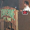
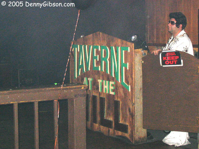
My motel was in the middle of a big chain restaurant cluster but I went to
the internet and located a few independent candidates for dinner. The
nearest worked just fine. The food was merely OK but, even though dinner
was the stated goal, I think finding the
Taverne at the Mill was a good bit of luck. What
better place to stop on the Saturday before Halloween than a haunted bar
with costume party planned? Real ghosts are reported to stop by the
Taverne from time to time and today some normal living folks are dressed
like the supposedly deceased. I didn't attempt to distinguish the two
groups.
|
|
 Only after reading through a local visitor's guide did I learn that I was
again in a county with a large covered bridge population. It isn't
entirely clear where Fairfield County ranks in the list of bridge
collections but I think it is second in Ohio and third in the country. The
printed guide claimed that it was second in the state with sixteen. The
excellent Ohio
Barns website, which covers a whole lot more than Ohio and a whole lot
more than barns, lists 19 for Fairfield County and 24 for Ashtabula
County. The ODOT site credits both
counties with 16. Of course, everybody recognizes Indiana's Parke County,
where I was last week, as number one
in the nation with 39 covered bridges.
Only after reading through a local visitor's guide did I learn that I was
again in a county with a large covered bridge population. It isn't
entirely clear where Fairfield County ranks in the list of bridge
collections but I think it is second in Ohio and third in the country. The
printed guide claimed that it was second in the state with sixteen. The
excellent Ohio
Barns website, which covers a whole lot more than Ohio and a whole lot
more than barns, lists 19 for Fairfield County and 24 for Ashtabula
County. The ODOT site credits both
counties with 16. Of course, everybody recognizes Indiana's Parke County,
where I was last week, as number one
in the nation with 39 covered bridges.
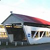
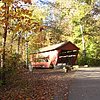
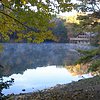
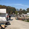
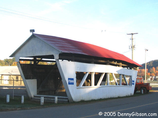
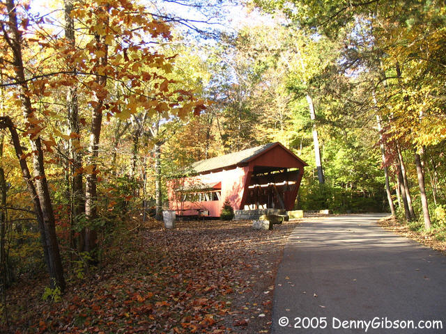
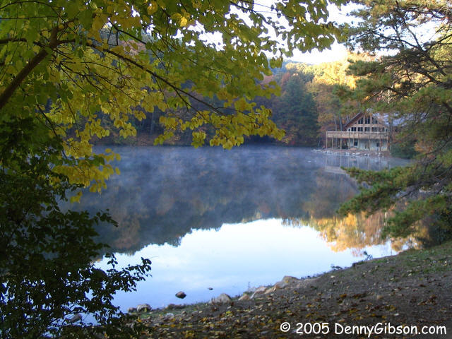
So, even though bridges were not the day's primary target and I've kind of
loaded up on them lately, I had to visit a couple. The closest and easiest
were Roley School House and George Hutchins bridges. Both have been moved
from their original locations and neither is open to anything other than
foot traffic. The Roley School House Bridge is currently just inside the
county fairgrounds in Lancaster and the George Hutchins Bridge is in Alley
Park a little south of town. The third picture is also in Alley Park
showing the lodge at the edge of lake Loretta.
|
|
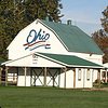
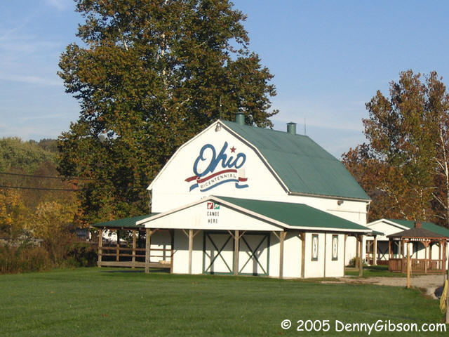
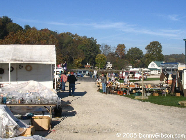
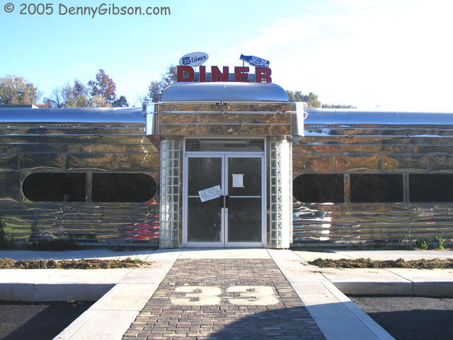
 I saw a bright silver diner off to the left of US-33 and decided that it
looked like a good place for breakfast. Then, when I pull up in front, I
saw that it's not yet open. Probably won't be until next spring according
to two fellows I talked to in the adjacent flea market. I strolled through
the not quite open market area - lots of "frosted" glassware - and got a
cup of coffee. I assume that the barn is the current official bicentennial
barn for Hocking County but I'm not 100% sure. Ohio's official
bicentennial website has been retired and this is not the barn pictured at
Ohio Barns. That site reports that the barn it shows
has been torn down so I'm guessing that this one is a replacement.
I saw a bright silver diner off to the left of US-33 and decided that it
looked like a good place for breakfast. Then, when I pull up in front, I
saw that it's not yet open. Probably won't be until next spring according
to two fellows I talked to in the adjacent flea market. I strolled through
the not quite open market area - lots of "frosted" glassware - and got a
cup of coffee. I assume that the barn is the current official bicentennial
barn for Hocking County but I'm not 100% sure. Ohio's official
bicentennial website has been retired and this is not the barn pictured at
Ohio Barns. That site reports that the barn it shows
has been torn down so I'm guessing that this one is a replacement.
|
|
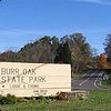

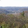
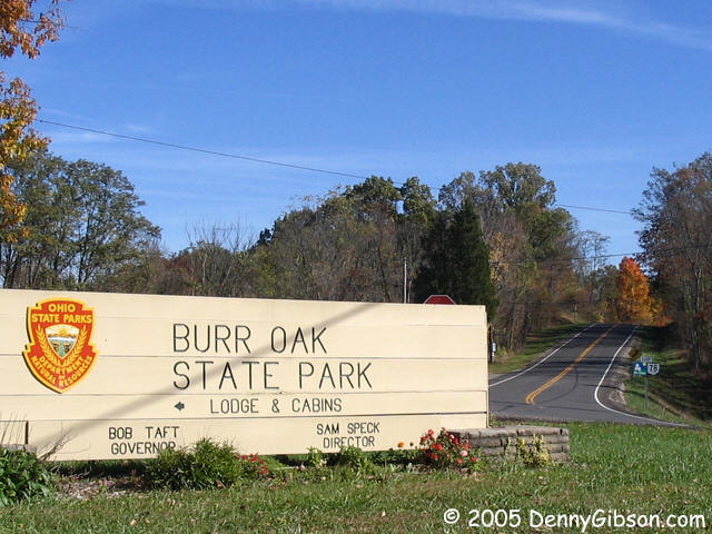
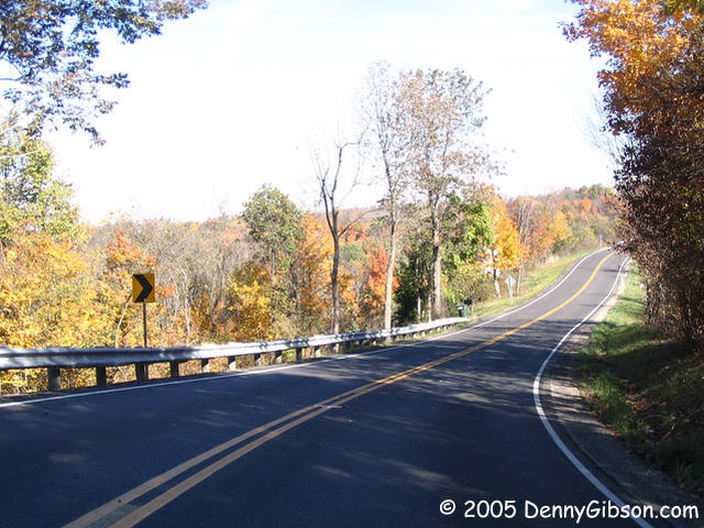
 OH-78 starts in Nelsonville and the Morgan County Scenic Byway starts
about eighteen miles east at Burr Oak State Park. The first scenic byway
sign is visible at the right side of the first picture. Between
Nelsonville and Morgan County, OH-78 passes through the towns of Murray
City and Glouster and crosses the Hocking-Athens county line no less than
four times. The Ohio
Byways site calls the section between the Burr Oak Park and the Wolf
Creek Wildlife Area "Rim of the World". There are some great views but I
don't think many will confuse it with the Rim of the World Highway in
California.
OH-78 starts in Nelsonville and the Morgan County Scenic Byway starts
about eighteen miles east at Burr Oak State Park. The first scenic byway
sign is visible at the right side of the first picture. Between
Nelsonville and Morgan County, OH-78 passes through the towns of Murray
City and Glouster and crosses the Hocking-Athens county line no less than
four times. The Ohio
Byways site calls the section between the Burr Oak Park and the Wolf
Creek Wildlife Area "Rim of the World". There are some great views but I
don't think many will confuse it with the Rim of the World Highway in
California.
|
|
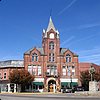
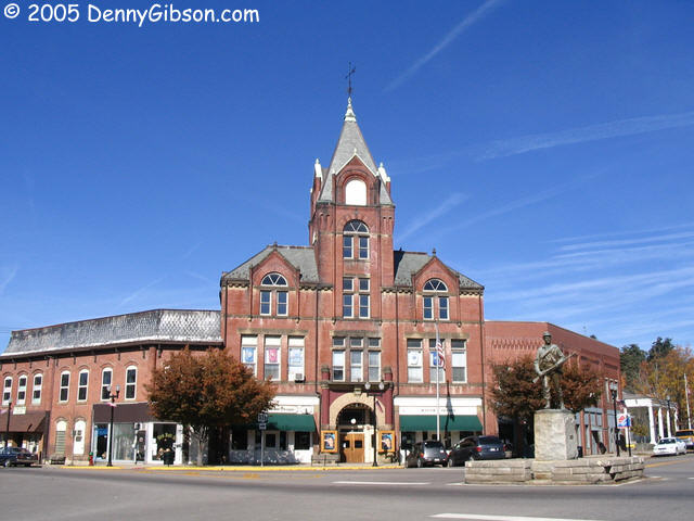
 The 1858 Morgan County Courthouse and 1890 Opera House form two sides of
McConnelsville's town diamond. It's not quite the same as a town square
since the surrounding buildings are set at an angle to the intersecting
streets so that the streets enter and exit the square/diamond at the
corners.
The 1858 Morgan County Courthouse and 1890 Opera House form two sides of
McConnelsville's town diamond. It's not quite the same as a town square
since the surrounding buildings are set at an angle to the intersecting
streets so that the streets enter and exit the square/diamond at the
corners.
|
|
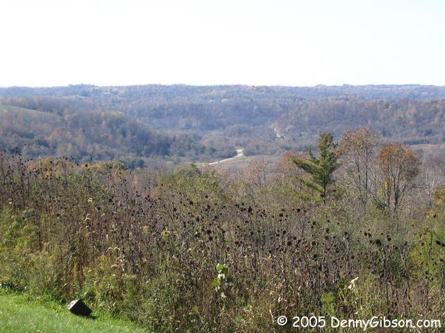
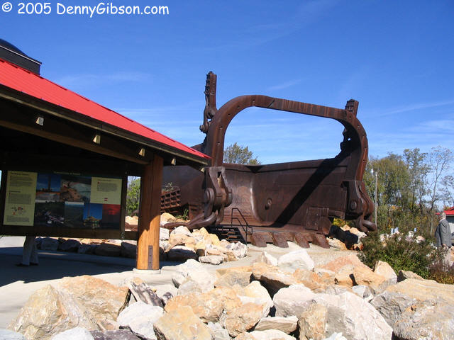
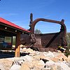 This scenic overlook is at
Miners Memorial Park. The thing that catches
everyone's attention at the park is the 220-cubic-yard bucket from the
Big
Muskie. The Big Muskie worked in nearby coal mining operations from
1969 until 1991 and, during that time, moved over twice the amount of
earth moved for the Panama Canal.
This scenic overlook is at
Miners Memorial Park. The thing that catches
everyone's attention at the park is the 220-cubic-yard bucket from the
Big
Muskie. The Big Muskie worked in nearby coal mining operations from
1969 until 1991 and, during that time, moved over twice the amount of
earth moved for the Panama Canal.
|
|
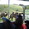
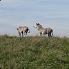

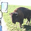

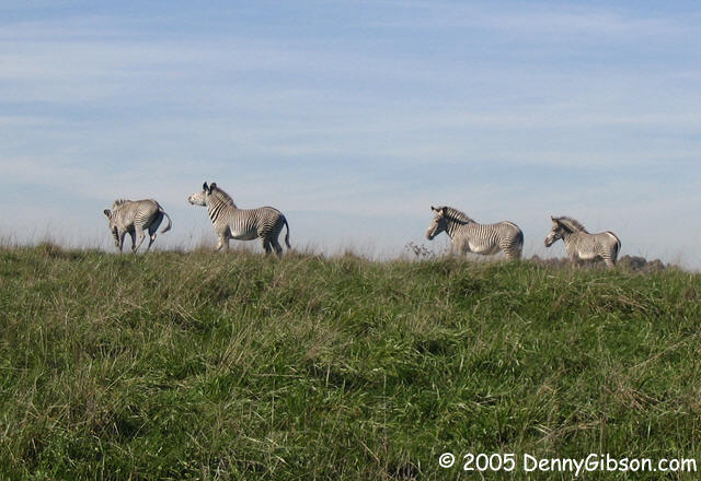
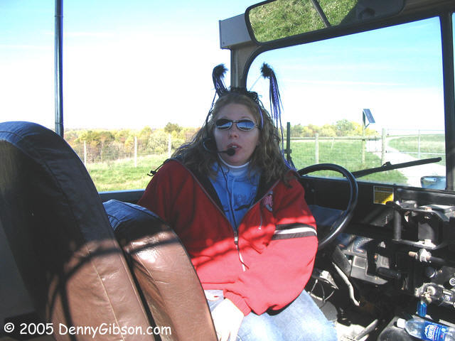
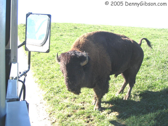
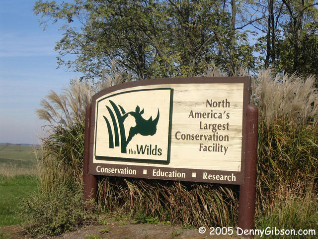
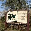 After a short stretch on OH-83, the byway follows OH-284 to the county
line. Just a half dozen miles into Muskingum, OH-284 goes by
The Wilds. Of course,
it was strip mining that the Big Muskie carried on and it made some mighty
big scars. In 1986 over 9,000 acres of that land were donated to the
International Center for the Preservation of Wild Animals and North
America's largest open-range preserve was born. Timing and weather were
just right for taking the open air tour although not too many others
seemed to think so. Guide Jaime had only me and a family of four to deal
with and we got a great tour. Some species (e.g., giraffes) were already
inside for the winter but we got to see many others up close and personal.
Note Jaime's special Halloween Eve head gear. With few exceptions, all
species at The Wilds are endangered and both the land and many threatened
animals are being benefited.
After a short stretch on OH-83, the byway follows OH-284 to the county
line. Just a half dozen miles into Muskingum, OH-284 goes by
The Wilds. Of course,
it was strip mining that the Big Muskie carried on and it made some mighty
big scars. In 1986 over 9,000 acres of that land were donated to the
International Center for the Preservation of Wild Animals and North
America's largest open-range preserve was born. Timing and weather were
just right for taking the open air tour although not too many others
seemed to think so. Guide Jaime had only me and a family of four to deal
with and we got a great tour. Some species (e.g., giraffes) were already
inside for the winter but we got to see many others up close and personal.
Note Jaime's special Halloween Eve head gear. With few exceptions, all
species at The Wilds are endangered and both the land and many threatened
animals are being benefited.
|
|
 Last week, as I drove through Indiana's Parke County, I often found myself
thinking that the trees were just about a week from peak color. Even more
frequently I thought how nice it would be if the sky wasn't three quarters
gray. I had similar thoughts about the trees in Brown County Ohio when I
visited there four weeks ago. Realizing that this weekend promised dry and
warm (for the end of October) weather, I first thought of heading back to
Brown County. Then I stopped by Ohio's Scenic Byway website and spotted
the Morgan County Scenic Byway south east of Columbus.
That looked inviting plus the area wouldn't be quite so familiar. So,
after a day at my Dad's, I headed east instead of south and spent the
night in Lancaster - about twenty miles from the east end of the byway.
Last week, as I drove through Indiana's Parke County, I often found myself
thinking that the trees were just about a week from peak color. Even more
frequently I thought how nice it would be if the sky wasn't three quarters
gray. I had similar thoughts about the trees in Brown County Ohio when I
visited there four weeks ago. Realizing that this weekend promised dry and
warm (for the end of October) weather, I first thought of heading back to
Brown County. Then I stopped by Ohio's Scenic Byway website and spotted
the Morgan County Scenic Byway south east of Columbus.
That looked inviting plus the area wouldn't be quite so familiar. So,
after a day at my Dad's, I headed east instead of south and spent the
night in Lancaster - about twenty miles from the east end of the byway.
 Only after reading through a local visitor's guide did I learn that I was
again in a county with a large covered bridge population. It isn't
entirely clear where Fairfield County ranks in the list of bridge
collections but I think it is second in Ohio and third in the country. The
printed guide claimed that it was second in the state with sixteen. The
excellent Ohio
Barns website, which covers a whole lot more than Ohio and a whole lot
more than barns, lists 19 for Fairfield County and 24 for Ashtabula
County. The ODOT site credits both
counties with 16. Of course, everybody recognizes Indiana's Parke County,
where I was last week, as number one
in the nation with 39 covered bridges.
Only after reading through a local visitor's guide did I learn that I was
again in a county with a large covered bridge population. It isn't
entirely clear where Fairfield County ranks in the list of bridge
collections but I think it is second in Ohio and third in the country. The
printed guide claimed that it was second in the state with sixteen. The
excellent Ohio
Barns website, which covers a whole lot more than Ohio and a whole lot
more than barns, lists 19 for Fairfield County and 24 for Ashtabula
County. The ODOT site credits both
counties with 16. Of course, everybody recognizes Indiana's Parke County,
where I was last week, as number one
in the nation with 39 covered bridges.
 I saw a bright silver diner off to the left of US-33 and decided that it
looked like a good place for breakfast. Then, when I pull up in front, I
saw that it's not yet open. Probably won't be until next spring according
to two fellows I talked to in the adjacent flea market. I strolled through
the not quite open market area - lots of "frosted" glassware - and got a
cup of coffee. I assume that the barn is the current official bicentennial
barn for Hocking County but I'm not 100% sure. Ohio's official
bicentennial website has been retired and this is not the barn pictured at
Ohio Barns. That site reports that the barn it shows
has been torn down so I'm guessing that this one is a replacement.
I saw a bright silver diner off to the left of US-33 and decided that it
looked like a good place for breakfast. Then, when I pull up in front, I
saw that it's not yet open. Probably won't be until next spring according
to two fellows I talked to in the adjacent flea market. I strolled through
the not quite open market area - lots of "frosted" glassware - and got a
cup of coffee. I assume that the barn is the current official bicentennial
barn for Hocking County but I'm not 100% sure. Ohio's official
bicentennial website has been retired and this is not the barn pictured at
Ohio Barns. That site reports that the barn it shows
has been torn down so I'm guessing that this one is a replacement.
 OH-78 starts in Nelsonville and the Morgan County Scenic Byway starts
about eighteen miles east at Burr Oak State Park. The first scenic byway
sign is visible at the right side of the first picture. Between
Nelsonville and Morgan County, OH-78 passes through the towns of Murray
City and Glouster and crosses the Hocking-Athens county line no less than
four times. The Ohio
Byways site calls the section between the Burr Oak Park and the Wolf
Creek Wildlife Area "Rim of the World". There are some great views but I
don't think many will confuse it with the Rim of the World Highway in
California.
OH-78 starts in Nelsonville and the Morgan County Scenic Byway starts
about eighteen miles east at Burr Oak State Park. The first scenic byway
sign is visible at the right side of the first picture. Between
Nelsonville and Morgan County, OH-78 passes through the towns of Murray
City and Glouster and crosses the Hocking-Athens county line no less than
four times. The Ohio
Byways site calls the section between the Burr Oak Park and the Wolf
Creek Wildlife Area "Rim of the World". There are some great views but I
don't think many will confuse it with the Rim of the World Highway in
California.
 The 1858 Morgan County Courthouse and 1890 Opera House form two sides of
McConnelsville's town diamond. It's not quite the same as a town square
since the surrounding buildings are set at an angle to the intersecting
streets so that the streets enter and exit the square/diamond at the
corners.
The 1858 Morgan County Courthouse and 1890 Opera House form two sides of
McConnelsville's town diamond. It's not quite the same as a town square
since the surrounding buildings are set at an angle to the intersecting
streets so that the streets enter and exit the square/diamond at the
corners.
 This scenic overlook is at
Miners Memorial Park. The thing that catches
everyone's attention at the park is the 220-cubic-yard bucket from the
Big
Muskie. The Big Muskie worked in nearby coal mining operations from
1969 until 1991 and, during that time, moved over twice the amount of
earth moved for the Panama Canal.
This scenic overlook is at
Miners Memorial Park. The thing that catches
everyone's attention at the park is the 220-cubic-yard bucket from the
Big
Muskie. The Big Muskie worked in nearby coal mining operations from
1969 until 1991 and, during that time, moved over twice the amount of
earth moved for the Panama Canal.


 After a short stretch on OH-83, the byway follows OH-284 to the county
line. Just a half dozen miles into Muskingum, OH-284 goes by
The Wilds. Of course,
it was strip mining that the Big Muskie carried on and it made some mighty
big scars. In 1986 over 9,000 acres of that land were donated to the
International Center for the Preservation of Wild Animals and North
America's largest open-range preserve was born. Timing and weather were
just right for taking the open air tour although not too many others
seemed to think so. Guide Jaime had only me and a family of four to deal
with and we got a great tour. Some species (e.g., giraffes) were already
inside for the winter but we got to see many others up close and personal.
Note Jaime's special Halloween Eve head gear. With few exceptions, all
species at The Wilds are endangered and both the land and many threatened
animals are being benefited.
After a short stretch on OH-83, the byway follows OH-284 to the county
line. Just a half dozen miles into Muskingum, OH-284 goes by
The Wilds. Of course,
it was strip mining that the Big Muskie carried on and it made some mighty
big scars. In 1986 over 9,000 acres of that land were donated to the
International Center for the Preservation of Wild Animals and North
America's largest open-range preserve was born. Timing and weather were
just right for taking the open air tour although not too many others
seemed to think so. Guide Jaime had only me and a family of four to deal
with and we got a great tour. Some species (e.g., giraffes) were already
inside for the winter but we got to see many others up close and personal.
Note Jaime's special Halloween Eve head gear. With few exceptions, all
species at The Wilds are endangered and both the land and many threatened
animals are being benefited.